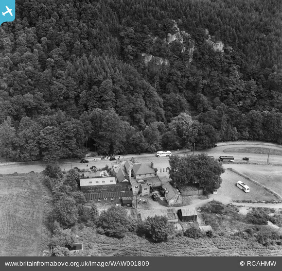
WAW001809 WALES (1946). View of Swallow Falls Hotel, Betws-y-Coed
© Copyright OpenStreetMap contributors and licensed by the OpenStreetMap Foundation. 2026. Cartography is licensed as CC BY-SA.
Nearby Images (9)
Details
| Title | [WAW001809] View of Swallow Falls Hotel, Betws-y-Coed |
| Reference | WAW001809 |
| Date | 11-July-1946 |
| Link | Coflein Archive Item 6413210 |
| Place name | |
| Parish | |
| District | |
| Country | WALES |
| Easting / Northing | 276548, 357688 |
| Longitude / Latitude | -3.8441426026899, 53.101791980334 |
| National Grid Reference | SH765577 |
Pins
Be the first to add a comment to this image!


![[WAW001808] View of Swallow Falls Hotel, Betws-y-Coed](http://britainfromabove.org.uk/sites/all/libraries/aerofilms-images/public/100x100/WAW/001/WAW001808.jpg)
![[WAW001809] View of Swallow Falls Hotel, Betws-y-Coed](http://britainfromabove.org.uk/sites/all/libraries/aerofilms-images/public/100x100/WAW/001/WAW001809.jpg)
![[WAW001810] View of Swallow Falls Hotel, Betws-y-Coed](http://britainfromabove.org.uk/sites/all/libraries/aerofilms-images/public/100x100/WAW/001/WAW001810.jpg)
![[WAW001811] View of Swallow Falls Hotel, Betws-y-Coed](http://britainfromabove.org.uk/sites/all/libraries/aerofilms-images/public/100x100/WAW/001/WAW001811.jpg)
![[WAW001812] View of Swallow Falls Hotel, Betws-y-Coed](http://britainfromabove.org.uk/sites/all/libraries/aerofilms-images/public/100x100/WAW/001/WAW001812.jpg)
![[WAW001813] View of Swallow Falls Hotel, Betws-y-Coed](http://britainfromabove.org.uk/sites/all/libraries/aerofilms-images/public/100x100/WAW/001/WAW001813.jpg)
![[WAW001814] View of Swallow Falls Hotel, Betws-y-Coed](http://britainfromabove.org.uk/sites/all/libraries/aerofilms-images/public/100x100/WAW/001/WAW001814.jpg)
![[WAW001815] View of Swallow Falls Hotel, Betws-y-Coed](http://britainfromabove.org.uk/sites/all/libraries/aerofilms-images/public/100x100/WAW/001/WAW001815.jpg)
![[WAW001816] View of Swallow Falls Hotel, Betws-y-Coed](http://britainfromabove.org.uk/sites/all/libraries/aerofilms-images/public/100x100/WAW/001/WAW001816.jpg)