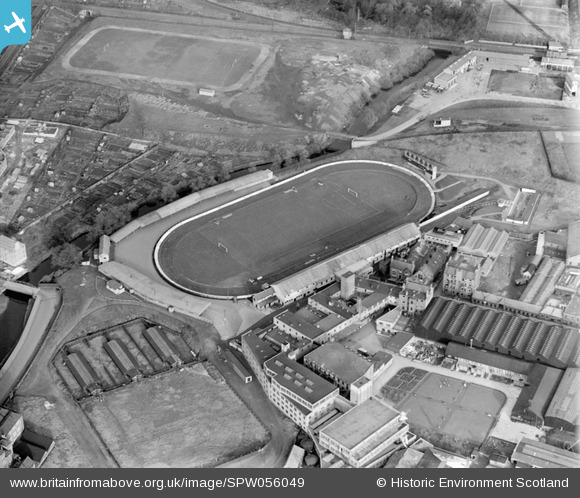
SPW056049 SCOTLAND (1937). Powderhall Stadium, Powderhall Road, Beaverbank, Edinburgh. An oblique aerial photograph taken facing north-east.
© Copyright OpenStreetMap contributors and licensed by the OpenStreetMap Foundation. 2026. Cartography is licensed as CC BY-SA.
Details
| Title | [SPW056049] Powderhall Stadium, Powderhall Road, Beaverbank, Edinburgh. An oblique aerial photograph taken facing north-east. |
| Reference | SPW056049 |
| Date | 1937 |
| Link | NRHE Collection item 1258155 |
| Place name | |
| Parish | EDINBURGH (EDINBURGH, CITY OF) |
| District | CITY OF EDINBURGH |
| Country | SCOTLAND |
| Easting / Northing | 325600, 675530 |
| Longitude / Latitude | -3.1920565643256, 55.967046498207 |
| National Grid Reference | NT256755 |
Pins

Andy A |
Sunday 17th of December 2017 12:40:13 PM | |

gBr |
Wednesday 19th of April 2017 02:27:29 PM | |

gBr |
Wednesday 19th of April 2017 02:26:43 PM | |

gBr |
Wednesday 19th of April 2017 02:00:23 PM | |

gBr |
Wednesday 19th of April 2017 01:57:22 PM | |

gBr |
Wednesday 19th of April 2017 01:28:55 PM | |

Andy A |
Wednesday 1st of January 2014 04:01:04 PM |


![[SPW056048] Powderhall Stadium, Powderhall Road, Beaverbank, Edinburgh. An oblique aerial photograph taken facing west.](http://britainfromabove.org.uk/sites/all/libraries/aerofilms-images/public/100x100/SPW/056/SPW056048.jpg)
![[SPW056049] Powderhall Stadium, Powderhall Road, Beaverbank, Edinburgh. An oblique aerial photograph taken facing north-east.](http://britainfromabove.org.uk/sites/all/libraries/aerofilms-images/public/100x100/SPW/056/SPW056049.jpg)