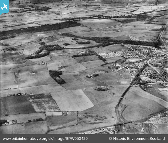
SPW053420 SCOTLAND (1937). General view, Bishopbriggs, Glasgow, Lanarkshire, Scotland, 1937. An oblique aerial photograph, taken facing north.
© Copyright OpenStreetMap contributors and licensed by the OpenStreetMap Foundation. 2025. Cartography is licensed as CC BY-SA.
Details
| Title | [SPW053420] General view, Bishopbriggs, Glasgow, Lanarkshire, Scotland, 1937. An oblique aerial photograph, taken facing north. |
| Reference | SPW053420 |
| Date | 1937 |
| Link | Canmore Collection item 1452075 |
| Place name | |
| Parish | GLASGOW (CITY OF GLASGOW) |
| District | CITY OF GLASGOW |
| Country | SCOTLAND |
| Easting / Northing | 259900, 669900 |
| Longitude / Latitude | -4.2411034383909, 55.9018275909 |
| National Grid Reference | NS599699 |
Pins
 MisKay |
Thursday 2nd of January 2020 02:30:47 PM | |
 MisKay |
Thursday 2nd of January 2020 02:29:34 PM | |
 MisKay |
Thursday 2nd of January 2020 02:28:56 PM | |
 ewnmcg |
Friday 15th of April 2016 01:44:47 PM | |
 ewnmcg |
Friday 15th of April 2016 01:43:31 PM | |
 ewnmcg |
Friday 15th of April 2016 01:42:31 PM | |
 ewnmcg |
Friday 15th of April 2016 01:40:10 PM | |
 ewnmcg |
Friday 15th of April 2016 01:38:38 PM | |
 John Mitchell |
Thursday 23rd of October 2014 02:41:29 PM |


![[SPW053419] General view, Bishopbriggs, Glasgow, Lanarkshire, Scotland, 1937. An oblique aerial photograph, taken facing north.](http://britainfromabove.org.uk/sites/all/libraries/aerofilms-images/public/100x100/SPW/053/SPW053419.jpg)
![[SPW053420] General view, Bishopbriggs, Glasgow, Lanarkshire, Scotland, 1937. An oblique aerial photograph, taken facing north.](http://britainfromabove.org.uk/sites/all/libraries/aerofilms-images/public/100x100/SPW/053/SPW053420.jpg)