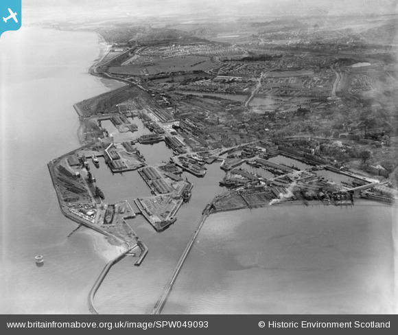
SPW049093 SCOTLAND (1935). Edinburgh, general view, showing Leith Docks and Leith Links. An oblique aerial photograph taken facing south.
© Copyright OpenStreetMap contributors and licensed by the OpenStreetMap Foundation. 2026. Cartography is licensed as CC BY-SA.
Nearby Images (22)
Details
| Title | [SPW049093] Edinburgh, general view, showing Leith Docks and Leith Links. An oblique aerial photograph taken facing south. |
| Reference | SPW049093 |
| Date | 1935 |
| Link | NRHE Collection item 1257993 |
| Place name | |
| Parish | EDINBURGH (EDINBURGH, CITY OF) |
| District | CITY OF EDINBURGH |
| Country | SCOTLAND |
| Easting / Northing | 327175, 676782 |
| Longitude / Latitude | -3.1671660835655, 55.978535784952 |
| National Grid Reference | NT272768 |
Pins

Andy A |
Sunday 27th of April 2014 10:12:33 PM |


![[SPW027117] Leith Docks, Edinburgh. An oblique aerial photograph taken facing east.](http://britainfromabove.org.uk/sites/all/libraries/aerofilms-images/public/100x100/SPW/027/SPW027117.jpg)
![[SPW049093] Edinburgh, general view, showing Leith Docks and Leith Links. An oblique aerial photograph taken facing south.](http://britainfromabove.org.uk/sites/all/libraries/aerofilms-images/public/100x100/SPW/049/SPW049093.jpg)
![[SPW049091] Edinburgh, general view, showing Leith Docks and Leith Links. An oblique aerial photograph taken facing south.](http://britainfromabove.org.uk/sites/all/libraries/aerofilms-images/public/100x100/SPW/049/SPW049091.jpg)
![[SPW027118] Leith Docks, Edinburgh. An oblique aerial photograph taken facing east.](http://britainfromabove.org.uk/sites/all/libraries/aerofilms-images/public/100x100/SPW/027/SPW027118.jpg)
![[SPW027119] Leith Docks, Edinburgh. An oblique aerial photograph taken facing east.](http://britainfromabove.org.uk/sites/all/libraries/aerofilms-images/public/100x100/SPW/027/SPW027119.jpg)
![[SPW027123] Leith Docks, Edinburgh. An oblique aerial photograph taken facing south-east.](http://britainfromabove.org.uk/sites/all/libraries/aerofilms-images/public/100x100/SPW/027/SPW027123.jpg)
![[SPW027121] Leith Docks, Edinburgh. An oblique aerial photograph taken facing east.](http://britainfromabove.org.uk/sites/all/libraries/aerofilms-images/public/100x100/SPW/027/SPW027121.jpg)
![[SPW022202] Leith Docks, Edinburgh. An oblique aerial photograph taken facing north.](http://britainfromabove.org.uk/sites/all/libraries/aerofilms-images/public/100x100/SPW/022/SPW022202.jpg)
![[SPW027116] Leith Docks, Edinburgh. An oblique aerial photograph taken facing north.](http://britainfromabove.org.uk/sites/all/libraries/aerofilms-images/public/100x100/SPW/027/SPW027116.jpg)
![[SPW049096] Albert and Imperial Docks, Leith, Edinburgh. An oblique aerial photograph taken facing north.](http://britainfromabove.org.uk/sites/all/libraries/aerofilms-images/public/100x100/SPW/049/SPW049096.jpg)
![[SPW022197] Leith Docks, Edinburgh. An oblique aerial photograph taken facing north.](http://britainfromabove.org.uk/sites/all/libraries/aerofilms-images/public/100x100/SPW/022/SPW022197.jpg)
![[SPW027122] Leith Docks, Edinburgh. An oblique aerial photograph taken facing east.](http://britainfromabove.org.uk/sites/all/libraries/aerofilms-images/public/100x100/SPW/027/SPW027122.jpg)
![[SPW022199] Leith Docks, Edinburgh. An oblique aerial photograph taken facing north-west.](http://britainfromabove.org.uk/sites/all/libraries/aerofilms-images/public/100x100/SPW/022/SPW022199.jpg)
![[SPW022201] Leith Docks, Edinburgh. An oblique aerial photograph taken facing north. This image has been produced from a damaged negative.](http://britainfromabove.org.uk/sites/all/libraries/aerofilms-images/public/100x100/SPW/022/SPW022201.jpg)
![[SPW049090] Leith Docks, Edinburgh. An oblique aerial photograph taken facing north-east.](http://britainfromabove.org.uk/sites/all/libraries/aerofilms-images/public/100x100/SPW/049/SPW049090.jpg)
![[SPW049104] Leith Docks, Edinburgh. An oblique aerial photograph taken facing north-east.](http://britainfromabove.org.uk/sites/all/libraries/aerofilms-images/public/100x100/SPW/049/SPW049104.jpg)
![[SPW022194] Leith Docks, Edinburgh. An oblique aerial photograph taken facing north.](http://britainfromabove.org.uk/sites/all/libraries/aerofilms-images/public/100x100/SPW/022/SPW022194.jpg)
![[SPW022200] Leith Docks, Edinburgh. An oblique aerial photograph taken facing north. This image has been produced from a damaged negative.](http://britainfromabove.org.uk/sites/all/libraries/aerofilms-images/public/100x100/SPW/022/SPW022200.jpg)
![[SPW049097] Leith Docks, Edinburgh. An oblique aerial photograph taken facing north.](http://britainfromabove.org.uk/sites/all/libraries/aerofilms-images/public/100x100/SPW/049/SPW049097.jpg)
![[SPW049101] Leith Docks, Edinburgh. An oblique aerial photograph taken facing north.](http://britainfromabove.org.uk/sites/all/libraries/aerofilms-images/public/100x100/SPW/049/SPW049101.jpg)
![[SPW040648] Edinburgh, general view, showing Garland and Roger Ltd. Timber Yard, Baltic Street and Leith Links. An oblique aerial photograph taken facing south.](http://britainfromabove.org.uk/sites/all/libraries/aerofilms-images/public/100x100/SPW/040/SPW040648.jpg)
![[SPW040650] Edinburgh, general view, showing Edinburgh Dock and Baltic Street. Leith, Edinburgh, Midlothian, Scotland, 1932. An oblique aerial photograph taken facing east. This image has been produced from a print.](http://britainfromabove.org.uk/sites/all/libraries/aerofilms-images/public/100x100/SPW/040/SPW040650.jpg)