
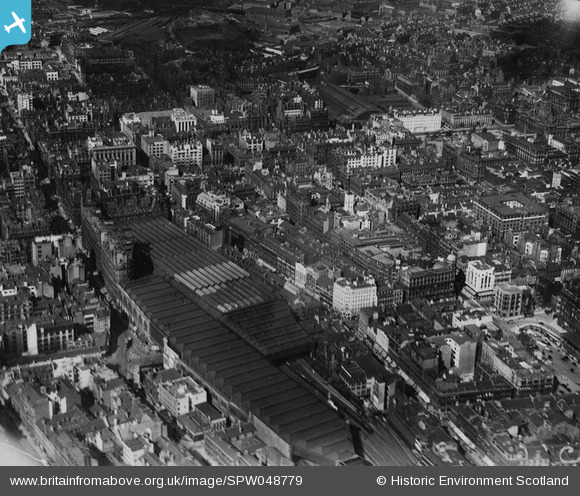
SPW048779 SCOTLAND (1935). Glasgow, general view, showing Central Station and Queen Street Station. An oblique aerial photograph taken facing north-east. This image has been produced from a print.
© Copyright OpenStreetMap contributors and licensed by the OpenStreetMap Foundation. 2026. Cartography is licensed as CC BY-SA.
Nearby Images (26)
SPW048779

SPW045886

SPW027203

SPW027196

SPW027201

SPW027192

SPW045890

SAR008721

SAR008791

SAR019240

SPW019464

SAW035931

SAW035933

SPW027199

SAR008654

SAR008655

SAR008656

SAR008658

SAR008659

SAR008660

SAR008661

SAR008662

SAR008666

SAR022291

SAR022292

SAR023826

Details
| Title | [SPW048779] Glasgow, general view, showing Central Station and Queen Street Station. An oblique aerial photograph taken facing north-east. This image has been produced from a print. |
| Reference | SPW048779 |
| Date | 1935 |
| Link | NRHE Collection item 1315586 |
| Place name | |
| Parish | GLASGOW (CITY OF GLASGOW) |
| District | CITY OF GLASGOW |
| Country | SCOTLAND |
| Easting / Northing | 258890, 665235 |
| Longitude / Latitude | -4.2548154593278, 55.859645831371 |
| National Grid Reference | NS589652 |
Pins
Be the first to add a comment to this image!