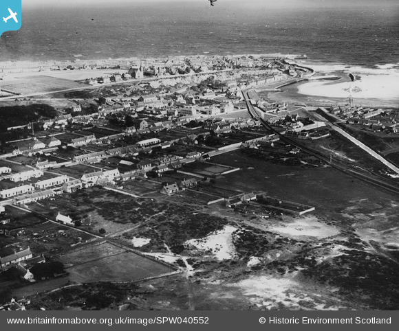
SPW040552 SCOTLAND (1932). Lossiemouth, general view, showing Moray Street and Prospect Terrace. An oblique aerial photograph taken facing north-east. This image has been produced from a print.
© Copyright OpenStreetMap contributors and licensed by the OpenStreetMap Foundation. 2026. Cartography is licensed as CC BY-SA.
Nearby Images (6)
Details
| Title | [SPW040552] Lossiemouth, general view, showing Moray Street and Prospect Terrace. An oblique aerial photograph taken facing north-east. This image has been produced from a print. |
| Reference | SPW040552 |
| Date | 1932 |
| Link | NRHE Collection item 1315543 |
| Place name | |
| Parish | DRAINIE |
| District | MORAY |
| Country | SCOTLAND |
| Easting / Northing | 323576, 870383 |
| Longitude / Latitude | -3.2829935059871, 57.716971709427 |
| National Grid Reference | NJ236704 |
Pins

Chris Souter |
Friday 17th of May 2024 02:38:17 PM | |

cell |
Sunday 23rd of June 2013 04:44:27 PM |
User Comment Contributions

cell |
Sunday 23rd of June 2013 04:47:32 PM |


![[SPW040552] Lossiemouth, general view, showing Moray Street and Prospect Terrace. An oblique aerial photograph taken facing north-east. This image has been produced from a print.](http://britainfromabove.org.uk/sites/all/libraries/aerofilms-images/public/100x100/SPW/040/SPW040552.jpg)
![[SAR016746] Lossiemouth Urquhart, Morayshire, Scotland. An oblique aerial photograph taken facing South/East.](http://britainfromabove.org.uk/sites/all/libraries/aerofilms-images/public/100x100/SAR/016/SAR016746.jpg)
![[SAR023868] Lossiemouth Urquhart, Morayshire, Scotland. An oblique aerial photograph taken facing South/East.](http://britainfromabove.org.uk/sites/all/libraries/aerofilms-images/public/100x100/SAR/023/SAR023868.jpg)
![[SAR023870] Lossiemouth Urquhart, Morayshire, Scotland. An oblique aerial photograph taken facing North. This image was marked by AeroPictorial Ltd for photo editing.](http://britainfromabove.org.uk/sites/all/libraries/aerofilms-images/public/100x100/SAR/023/SAR023870.jpg)
![[SAR033425] General View Urquhart, Morayshire, Scotland. An oblique aerial photograph taken facing North.](http://britainfromabove.org.uk/sites/all/libraries/aerofilms-images/public/100x100/SAR/033/SAR033425.jpg)
![[SAR033426] General View Urquhart, Morayshire, Scotland. An oblique aerial photograph taken facing North. This image was marked by AeroPictorial Ltd for photo editing.](http://britainfromabove.org.uk/sites/all/libraries/aerofilms-images/public/100x100/SAR/033/SAR033426.jpg)
