
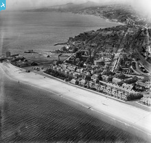
SPW040476 SCOTLAND (1932). Broughty Ferry, general view, showing Broughty Castle and The Esplanade. An oblique aerial photograph taken facing west.

© Copyright OpenStreetMap contributors and licensed by the OpenStreetMap Foundation. 2026. Cartography is licensed as CC BY-SA.
Nearby Images (2)
SPW040476

SPW019951

Details
| Title | [SPW040476] Broughty Ferry, general view, showing Broughty Castle and The Esplanade. An oblique aerial photograph taken facing west. |
| Reference | SPW040476 |
| Date | 1932 |
| Link | NRHE Collection item 1257507 |
| Place name | |
| Parish | DUNDEE (DUNDEE, CITY OF) |
| District | CITY OF DUNDEE |
| Country | SCOTLAND |
| Easting / Northing | 346722, 730637 |
| Longitude / Latitude | -2.8647610143056, 56.464958797786 |
| National Grid Reference | NO467306 |
Pins

Stobieer |
Sunday 19th of January 2014 10:52:42 PM | |
|
cell |
Saturday 28th of July 2012 01:22:47 PM | |
This is not Broughty Ferry power station electricity works, it is Broughty Ferry Gas Works. The gasometer is a big clue. |
John |
Thursday 31st of December 2020 09:04:24 PM |
|
TamSime |
Sunday 1st of July 2012 11:56:45 PM | |
The railway line did not go to the castle but went to station on the pier opposite the castle also in this picture the terminated at Brook Street and became sidings in the goods yard. |
John |
Thursday 31st of December 2020 09:08:51 PM |
User Comment Contributions
Broughty Ferry Power Station Electricity Works built by the Broughty Ferry Town Council in 1902 |
cell |
Saturday 28th of July 2012 01:24:24 PM |