
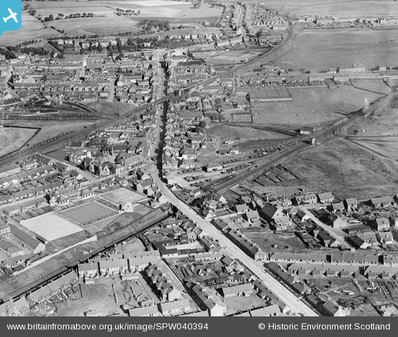
SPW040394 SCOTLAND (1932). Cowdenbeath, general view, showing Bridge Street and High Street. An oblique aerial photograph taken facing north.
© Copyright OpenStreetMap contributors and licensed by the OpenStreetMap Foundation. 2026. Cartography is licensed as CC BY-SA.
Nearby Images (3)
SPW040394

SPW040397

SPW040396

Details
| Title | [SPW040394] Cowdenbeath, general view, showing Bridge Street and High Street. An oblique aerial photograph taken facing north. |
| Reference | SPW040394 |
| Date | 1932 |
| Link | NRHE Collection item 1257461 |
| Place name | |
| Parish | BEATH |
| District | DUNFERMLINE |
| Country | SCOTLAND |
| Easting / Northing | 316660, 691350 |
| Longitude / Latitude | -3.3401707727883, 56.107693270191 |
| National Grid Reference | NT167914 |
Pins

NorthChurch |
Monday 13th of April 2020 02:47:03 PM | |
|
NorthChurch |
Monday 13th of April 2020 02:45:17 PM | |
|
Canonach |
Friday 5th of September 2014 09:24:05 PM | |
|
Canonach |
Friday 5th of September 2014 09:19:42 PM | |
|
Andy A |
Thursday 2nd of January 2014 08:37:16 PM | |
|
Andy A |
Thursday 2nd of January 2014 08:33:18 PM | |
This is No 7 pit, number 8 was west of here. |
Canonach |
Thursday 11th of September 2014 11:30:16 AM |