
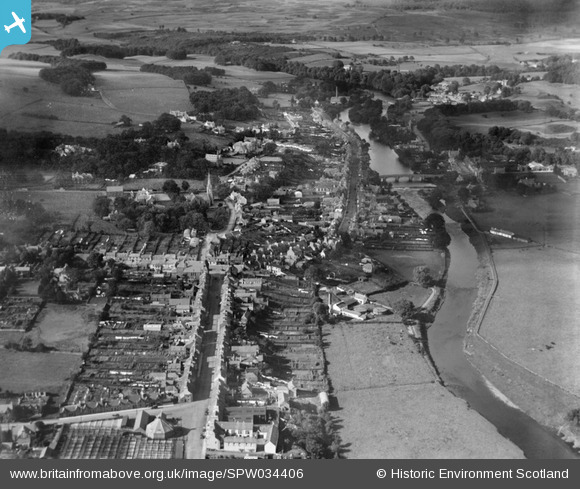
SPW034406 SCOTLAND (1930). Newton Stewart, general view, showing Victoria Street and Queen Street. An oblique aerial photograph taken facing north.
© Copyright OpenStreetMap contributors and licensed by the OpenStreetMap Foundation. 2026. Cartography is licensed as CC BY-SA.
Nearby Images (4)
SPW034406

SPW034407

SPW034399

SPW034405

Details
| Title | [SPW034406] Newton Stewart, general view, showing Victoria Street and Queen Street. An oblique aerial photograph taken facing north. |
| Reference | SPW034406 |
| Date | 1930 |
| Link | NRHE Collection item 1257137 |
| Place name | |
| Parish | PENNINGHAME |
| District | WIGTOWN |
| Country | SCOTLAND |
| Easting / Northing | 241120, 565395 |
| Longitude / Latitude | -4.4816190490532, 54.957756508807 |
| National Grid Reference | NX411654 |
Pins

GarryDIrvine |
Saturday 24th of October 2020 03:05:53 PM | |
|
MB |
Thursday 18th of October 2012 08:02:28 PM | |
|
MB |
Thursday 18th of October 2012 08:01:39 PM | |
|
MB |
Thursday 18th of October 2012 08:01:15 PM | |
|
MB |
Thursday 18th of October 2012 08:00:52 PM | |
|
MB |
Thursday 18th of October 2012 07:57:35 PM | |
|
MB |
Thursday 18th of October 2012 07:56:19 PM | |
|
MB |
Thursday 18th of October 2012 07:54:37 PM | |
|
MB |
Thursday 18th of October 2012 07:53:29 PM | |
|
MB |
Thursday 18th of October 2012 07:52:31 PM |