
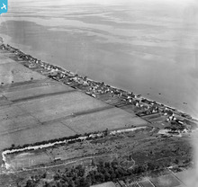
SPW033796 SCOTLAND (1930). Saltburn, Invergordon, general view. An oblique aerial photograph taken facing east. This image has been produced from a damaged negative.

© Copyright OpenStreetMap contributors and licensed by the OpenStreetMap Foundation. 2026. Cartography is licensed as CC BY-SA.
Details
| Title | [SPW033796] Saltburn, Invergordon, general view. An oblique aerial photograph taken facing east. This image has been produced from a damaged negative. |
| Reference | SPW033796 |
| Date | 1930 |
| Link | NRHE Collection item 1298007 |
| Place name | |
| Parish | ROSSKEEN |
| District | ROSS AND CROMARTY |
| Country | SCOTLAND |
| Easting / Northing | 272550, 869830 |
| Longitude / Latitude | -4.1387708232855, 57.700436937359 |
| National Grid Reference | NH726698 |
Pins
Be the first to add a comment to this image!
User Comment Contributions
61 houses on this site are marked in the First (1880) Edition of the Ordnance Survey map for the area. |

AlMu |
Thursday 6th of December 2012 10:20:25 AM |