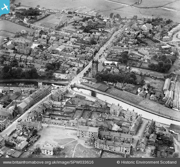
SPW033616 SCOTLAND (1930). Kirkintilloch, general view, showing St Mary's Parish Church, Cowgate and Forth and Clyde Canal. An oblique aerial photograph taken facing north-west.
    © Copyright OpenStreetMap contributors and licensed by the OpenStreetMap Foundation. 2025. Cartography is licensed as CC BY-SA.
  
Nearby Images (7)
Details
| Title | [SPW033616] Kirkintilloch, general view, showing St Mary's Parish Church, Cowgate and Forth and Clyde Canal. An oblique aerial photograph taken facing north-west. | 
| Reference | SPW033616 | 
| Date | 1930 | 
| Link | NRHE Collection item 1259371 | 
| Place name | |
| Parish | KIRKINTILLOCH (STRATHKELVIN) | 
| District | STRATHKELVIN | 
| Country | SCOTLAND | 
| Easting / Northing | 265475, 673891 | 
| Longitude / Latitude | -4.1539827082401, 55.939254822694 | 
| National Grid Reference | NS655739 | 
Pins
Be the first to add a comment to this image!
 
             
  ![[SPW033615] Kirkintilloch, general view, showing St Mary's Parish Church, Cowgate and Kerr Street.  An oblique aerial photograph taken facing south-west.](http://britainfromabove.org.uk/sites/all/libraries/aerofilms-images/public/100x100/SPW/033/SPW033615.jpg) 
  
                                          ![[SPW033616] Kirkintilloch, general view, showing St Mary's Parish Church, Cowgate and Forth and Clyde Canal.  An oblique aerial photograph taken facing north-west.](http://britainfromabove.org.uk/sites/all/libraries/aerofilms-images/public/100x100/SPW/033/SPW033616.jpg) 
 ![[SPW056743] Kirkintilloch, general view, showing Forth and Clyde Canal and Kilsyth Road.  An oblique aerial photograph taken facing south.](http://britainfromabove.org.uk/sites/all/libraries/aerofilms-images/public/100x100/SPW/056/SPW056743.jpg) 
 ![[SPW033617] Kirkintilloch, general view, showing Cowgate and Kerr Street.  An oblique aerial photograph taken facing south.](http://britainfromabove.org.uk/sites/all/libraries/aerofilms-images/public/100x100/SPW/033/SPW033617.jpg) 
 ![[SPW056742] Kirkintilloch, general view, showing Forth and Clyde Canal and St Mary's Parish Church, Cowgate.  An oblique aerial photograph taken facing south.](http://britainfromabove.org.uk/sites/all/libraries/aerofilms-images/public/100x100/SPW/056/SPW056742.jpg) 
 ![[SPW033618] Kirkintilloch, general view, showing Kerr Street and St Mary's Parish Church, Cowgate.  An oblique aerial photograph taken facing east.](http://britainfromabove.org.uk/sites/all/libraries/aerofilms-images/public/100x100/SPW/033/SPW033618.jpg) 
 ![[SPW033619] Kirkintilloch, general view, showing Old Church, Cowgate and High Street.  An oblique aerial photograph taken facing south.](http://britainfromabove.org.uk/sites/all/libraries/aerofilms-images/public/100x100/SPW/033/SPW033619.jpg)