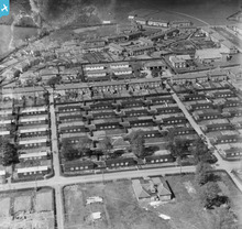
SPW027440 SCOTLAND (1929). Gretna, general view, showing Annan Road and Union Road. An oblique aerial photograph taken facing north. This image has been produced from a damaged negative.
© Copyright OpenStreetMap contributors and licensed by the OpenStreetMap Foundation. 2026. Cartography is licensed as CC BY-SA.
Details
| Title | [SPW027440] Gretna, general view, showing Annan Road and Union Road. An oblique aerial photograph taken facing north. This image has been produced from a damaged negative. |
| Reference | SPW027440 |
| Date | 1929 |
| Link | NRHE Collection item 1256881 |
| Place name | |
| Parish | GRETNA |
| District | ANNANDALE AND ESKDALE |
| Country | SCOTLAND |
| Easting / Northing | 331754, 567303 |
| Longitude / Latitude | -3.0668744698319, 54.995550525483 |
| National Grid Reference | NY318673 |
Pins
User Comment Contributions
Lynda Tubbs |
Thursday 10th of July 2014 03:04:05 PM | |
Shows munitions workers housing. Find a guide to this fascinating development at http://www.historic-scotland.gov.uk/gretna |
Lynda Tubbs |
Thursday 10th of July 2014 02:57:47 PM |


![[SPW027440] Gretna, general view, showing Annan Road and Union Road. An oblique aerial photograph taken facing north. This image has been produced from a damaged negative.](http://britainfromabove.org.uk/sites/all/libraries/aerofilms-images/public/100x100/SPW/027/SPW027440.jpg)
![[SPW027442] Gretna, general view, showing The Institute and All Saints Episcopal Church. An oblique aerial photograph taken facing south-east. This image has been produced from a damaged negative.](http://britainfromabove.org.uk/sites/all/libraries/aerofilms-images/public/100x100/SPW/027/SPW027442.jpg)
![[SPW027435] Gretna, general view, showing The Institute and All Saints Episcopal Church. An oblique aerial photograph taken facing north.](http://britainfromabove.org.uk/sites/all/libraries/aerofilms-images/public/100x100/SPW/027/SPW027435.jpg)

