
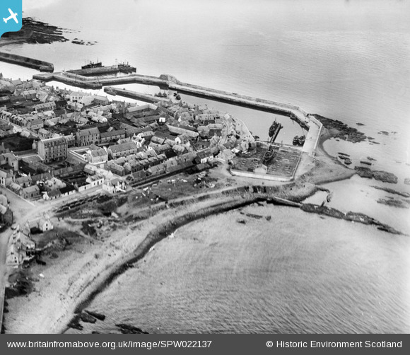
SPW022137 SCOTLAND (1928). Macduff, general view, showing Princess Royal Basin and Low Shore. An oblique aerial photograph taken facing west.
© Copyright OpenStreetMap contributors and licensed by the OpenStreetMap Foundation. 2026. Cartography is licensed as CC BY-SA.
Nearby Images (5)
SPW022137

SPW040541

SPW022136

SPW040542

SPW022134

Details
| Title | [SPW022137] Macduff, general view, showing Princess Royal Basin and Low Shore. An oblique aerial photograph taken facing west. |
| Reference | SPW022137 |
| Date | 1928 |
| Link | NRHE Collection item 1256507 |
| Place name | |
| Parish | GAMRIE |
| District | BANFF AND BUCHAN |
| Country | SCOTLAND |
| Easting / Northing | 370580, 864800 |
| Longitude / Latitude | -2.4932763152513, 57.672355474367 |
| National Grid Reference | NJ706648 |
Pins
Be the first to add a comment to this image!
User Comment Contributions
the princess royal basin which you see in this photo started to build in 1914 and was halted three weeks later due to the outbreak of ww1.slow progress was made because of this due to lack of labour and materials but was finally completed in 1921 at a cost of £50000.the slipway was completed in 1922 at a cost of £19000. our harbour is still macduff's biggest asset with macduff's main employment at the local shipyard.sad to say the town i am afraid would be totally dead without this. |

stanley west |
Saturday 7th of July 2012 03:34:20 PM |
if you look at the right hand side of the photo you will see a narrow strip of rocks and like a pole sticking up from it. this is actually the funnel of an old scrapped herring drifter which was purposely placed there and filled with concrete to act as barrier against the sea. |
stanley west |
Saturday 7th of July 2012 03:16:39 PM |