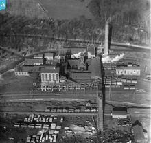
SPW020309 SCOTLAND (1928). Valleyfield Colliery, Low Valleyfield, Culross. An oblique aerial photograph taken facing north.
© Copyright OpenStreetMap contributors and licensed by the OpenStreetMap Foundation. 2026. Cartography is licensed as CC BY-SA.
Details
| Title | [SPW020309] Valleyfield Colliery, Low Valleyfield, Culross. An oblique aerial photograph taken facing north. |
| Reference | SPW020309 |
| Date | 1928 |
| Link | NRHE Collection item 1259344 |
| Place name | |
| Parish | CULROSS |
| District | DUNFERMLINE |
| Country | SCOTLAND |
| Easting / Northing | 300984, 686396 |
| Longitude / Latitude | -3.5903173705116, 56.060204001562 |
| National Grid Reference | NT010864 |
Pins

Andy A |
Monday 6th of January 2014 11:06:52 AM |
User Comment Contributions

cell |
Sunday 16th of February 2014 04:33:00 PM |


