
SPW020258 SCOTLAND (1928). Stirling, general view, showing Stirling Castle and Gowan Hill. An oblique aerial photograph taken facing east.

© Copyright OpenStreetMap contributors and licensed by the OpenStreetMap Foundation. 2026. Cartography is licensed as CC BY-SA.
Nearby Images (9)
SPW020258

SAW024466

SPW020254

SAR008644

SAR013039

SAR018753

SAR018754

SPW040344

SAR013040

Details
| Title | [SPW020258] Stirling, general view, showing Stirling Castle and Gowan Hill. An oblique aerial photograph taken facing east. |
| Reference | SPW020258 |
| Date | 1928 |
| Link | NRHE Collection item 1256664 |
| Place name | |
| Parish | STIRLING |
| District | STIRLING |
| Country | SCOTLAND |
| Easting / Northing | 278984, 694096 |
| Longitude / Latitude | -3.9469424120541, 56.124296728618 |
| National Grid Reference | NS790941 |
Pins

Zebulon Vinge |
Friday 1st of June 2012 02:19:05 PM | |
|
Zebulon Vinge |
Friday 1st of June 2012 02:17:43 PM |
User Comment Contributions
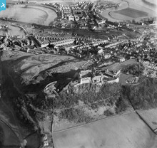
There has been a castle here since at least the 1100s and probably much earlier. The first written record is from 1110, when king Alexander I dedicated a chapel at the castle. |
Cat |
Tuesday 23rd of September 2014 07:21:54 AM |
Where Tesco is now sited (in Wallace Street) used to be in the 50/60s Fergusons Coal Merchant Yard.Next door to them was the Rossleigh Garage that sold /repaired Rootes Group(Standard, Triumph,Hillman,Singer,Sunbeam) and Jaguar vehicles. Further up the road was the cattle market. |
Chris |
Wednesday 27th of June 2012 12:25:22 PM |
River Forth is in flood if you look closely. |
Chris |
Wednesday 27th of June 2012 12:10:34 PM |