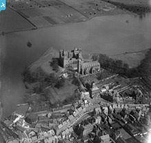
SPW017716 SCOTLAND (1927). Linlithgow Palace, St Michael's Church and Loch. An oblique aerial photograph taken facing north.
© Copyright OpenStreetMap contributors and licensed by the OpenStreetMap Foundation. 2026. Cartography is licensed as CC BY-SA.
Details
| Title | [SPW017716] Linlithgow Palace, St Michael's Church and Loch. An oblique aerial photograph taken facing north. |
| Reference | SPW017716 |
| Date | 1927 |
| Link | NRHE Collection item 1256147 |
| Place name | |
| Parish | LINLITHGOW |
| District | WEST LOTHIAN |
| Country | SCOTLAND |
| Easting / Northing | 300196, 677325 |
| Longitude / Latitude | -3.5995958416651, 55.978562716449 |
| National Grid Reference | NT002773 |
Pins

Gordon Sandford |
Friday 7th of October 2016 10:02:01 PM | |

Ag |
Monday 23rd of November 2015 10:48:50 PM | |

Ag |
Monday 23rd of November 2015 10:47:45 PM | |

Ag |
Monday 23rd of November 2015 10:40:12 PM | |

Ag |
Monday 23rd of November 2015 10:36:31 PM | |

Ag |
Monday 23rd of November 2015 10:34:16 PM | |

Ag |
Monday 23rd of November 2015 10:32:16 PM | |

Ag |
Monday 23rd of November 2015 10:24:42 PM | |

Ag |
Monday 23rd of November 2015 10:18:04 PM | |

Ag |
Monday 23rd of November 2015 10:10:22 PM | |

AlastairG |
Thursday 4th of July 2013 11:18:51 PM | |

AlastairG |
Thursday 4th of July 2013 11:16:02 PM | |

AlastairG |
Thursday 4th of July 2013 02:50:02 PM | |

Brian Wilkinson |
Tuesday 31st of July 2012 12:54:29 PM | |
The core of the structure is laminated wood. The aluminium cladding was originally anodised in a gold pigment but this has weathered, leaving the crown silver. |

Ag |
Monday 23rd of November 2015 10:50:55 PM |

Brian Wilkinson |
Tuesday 31st of July 2012 11:32:26 AM | |

Brian Wilkinson |
Tuesday 31st of July 2012 11:32:06 AM | |

Brian Wilkinson |
Monday 30th of July 2012 01:12:34 PM |
User Comment Contributions

Class31 |
Wednesday 24th of April 2013 11:06:33 AM | |

Brian Wilkinson |
Tuesday 31st of July 2012 11:33:52 AM |


![[SPW017716] Linlithgow Palace, St Michael's Church and Loch. An oblique aerial photograph taken facing north.](http://britainfromabove.org.uk/sites/all/libraries/aerofilms-images/public/100x100/SPW/017/SPW017716.jpg)
![[SPW027085] Linlithgow, general view, showing Linlithgow Palace, St Michael's Church and Loch. An oblique aerial photograph taken facing east.](http://britainfromabove.org.uk/sites/all/libraries/aerofilms-images/public/100x100/SPW/027/SPW027085.jpg)
![[SPW027084] Linlithgow, general view, showing Linlithgow Palace, St Michael's Church and Loch. An oblique aerial photograph taken facing north.](http://britainfromabove.org.uk/sites/all/libraries/aerofilms-images/public/100x100/SPW/027/SPW027084.jpg)

