
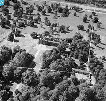
SAW046310 SCOTLAND (1952). Scone Palace and Mote Church, Boot Hill. An oblique aerial photograph taken facing south-west. This image has been produced from a crop marked negative.

© Copyright OpenStreetMap contributors and licensed by the OpenStreetMap Foundation. 2026. Cartography is licensed as CC BY-SA.
Nearby Images (6)
SAW046310

SAR014750

SAW046311

SAW046312

SAW046313

SAW046314

Details
| Title | [SAW046310] Scone Palace and Mote Church, Boot Hill. An oblique aerial photograph taken facing south-west. This image has been produced from a crop marked negative. |
| Reference | SAW046310 |
| Date | 1952 |
| Link | NRHE Collection item 1297723 |
| Place name | |
| Parish | SCONE |
| District | PERTH AND KINROSS |
| Country | SCOTLAND |
| Easting / Northing | 311418, 726636 |
| Longitude / Latitude | -3.4362646094389, 56.423708651286 |
| National Grid Reference | NO114266 |
Pins
Be the first to add a comment to this image!
User Comment Contributions
Scone Palace and Boot/Moot Hill |

heavenstobetsie |
Tuesday 26th of June 2012 09:53:13 AM |