
SAW039389 SCOTLAND (1951). Beinn Nuis and Beinn Tarsuinn, Isle of Arran. An oblique aerial photograph taken facing north-west. This image has been produced from a print.

© Copyright OpenStreetMap contributors and licensed by the OpenStreetMap Foundation. 2026. Cartography is licensed as CC BY-SA.
Details
| Title | [SAW039389] Beinn Nuis and Beinn Tarsuinn, Isle of Arran. An oblique aerial photograph taken facing north-west. This image has been produced from a print. |
| Reference | SAW039389 |
| Date | 1951 |
| Link | NRHE Collection item 1315301 |
| Place name | |
| Parish | KILBRIDE |
| District | CUNNINGHAME |
| Country | SCOTLAND |
| Easting / Northing | 195542, 639890 |
| Longitude / Latitude | -5.2465607099784, 55.609574044333 |
| National Grid Reference | NR955399 |
Pins
Be the first to add a comment to this image!
User Comment Contributions
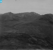
Another view of Glen Rosa, this time focusing on a higher area of the glen and clearly showing another characteristic glaciated feature, a 'hanging valley'. This is the high bowl-shaped corrie just underneath the skyline to the left of the centre of the photograph. Hanging valleys are formed when a smaller, tributary glacier flow meets the main glacier flow that has carved out the central glen to create the main U-shaped valley. |

AlMu |
Thursday 8th of May 2014 05:31:35 PM |