
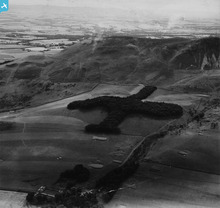
SAW039282 SCOTLAND (1951). Lothianburn Golf Course and Caerketton Hill, Edinburgh. An oblique aerial photograph taken facing south. This image has been produced from a print.

© Copyright OpenStreetMap contributors and licensed by the OpenStreetMap Foundation. 2026. Cartography is licensed as CC BY-SA.
Details
| Title | [SAW039282] Lothianburn Golf Course and Caerketton Hill, Edinburgh. An oblique aerial photograph taken facing south. This image has been produced from a print. |
| Reference | SAW039282 |
| Date | 1951 |
| Link | NRHE Collection item 1315268 |
| Place name | |
| Parish | DUNDEE (DUNDEE, CITY OF) |
| District | CITY OF DUNDEE |
| Country | SCOTLAND |
| Easting / Northing | 344900, 731200 |
| Longitude / Latitude | -2.894448996414, 56.469807305203 |
| National Grid Reference | NO449312 |
Pins
Be the first to add a comment to this image!
User Comment Contributions
Location details (above right) are quite wrong. NGR NT 2400066820 (centre of T wood) and the rest will follow |

GB |
Friday 25th of April 2014 07:15:32 PM |
I was sure I saw this knitting design somewhere before! |
Brian Wilkinson |
Thursday 14th of November 2013 11:59:05 AM |
|
Shows a scene to the south of Edinburgh but located far away... |
Alan McFarlane |
Tuesday 4th of June 2013 12:02:54 PM |
Thanks for pointing out all these anomalies Alan. It looks like a gremlin got in the works during the last upload. I will inform colleagues and see if we cannot get this sorted. Best wishes, Brian Brian Wilkinson Britain from Above Activity Officer (Scotland) |
Brian Wilkinson |
Tuesday 4th of June 2013 12:02:54 PM |
Should be at NT239668 or thereabouts. |
Alan McFarlane |
Tuesday 21st of May 2013 02:47:07 PM |