
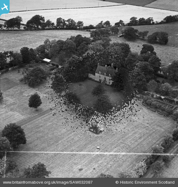
SAW032087 SCOTLAND (1950). Pilmuir House and Dovecot, Haddington. An oblique aerial photograph taken facing north-west. This image has been produced from a damaged and crop marked negative.
© Copyright OpenStreetMap contributors and licensed by the OpenStreetMap Foundation. 2026. Cartography is licensed as CC BY-SA.
Nearby Images (3)
SAW032086

SAW032087

SAW032088

Details
| Title | [SAW032087] Pilmuir House and Dovecot, Haddington. An oblique aerial photograph taken facing north-west. This image has been produced from a damaged and crop marked negative. |
| Reference | SAW032087 |
| Date | 1950 |
| Link | NRHE Collection item 1269675 |
| Place name | |
| Parish | BOLTON |
| District | EAST LOTHIAN |
| Country | SCOTLAND |
| Easting / Northing | 348633, 669355 |
| Longitude / Latitude | -2.8218923405163, 55.91458083027 |
| National Grid Reference | NT486694 |
Pins

incony |
Wednesday 25th of July 2018 04:11:01 PM | |
|
Alan McFarlane |
Friday 15th of June 2012 09:14:18 AM | |
|
Alan McFarlane |
Friday 15th of June 2012 09:13:40 AM |
User Comment Contributions
Three gardeners interrupted from their work to stand and stare. One man and two boys. Are they using an early mower, or maybe its some sort of scarifier? |
Alan McFarlane |
Friday 29th of June 2012 02:17:37 AM |
Thats a great stand and stare. Looks like a lawn roller to me? |
SteveAUS |
Friday 29th of June 2012 02:17:37 AM |