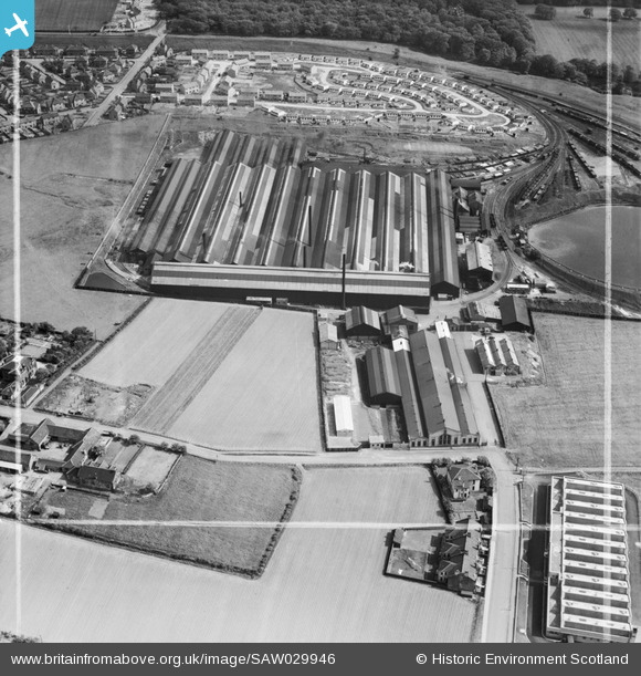
SAW029946 SCOTLAND (1950). Stewarts and Lloyds Ltd. Imperial Tube Works, Coatbridge. An oblique aerial photograph taken facing south-east. This image has been produced from a crop marked negative.
© Copyright OpenStreetMap contributors and licensed by the OpenStreetMap Foundation. 2026. Cartography is licensed as CC BY-SA.
Nearby Images (12)
Details
| Title | [SAW029946] Stewarts and Lloyds Ltd. Imperial Tube Works, Coatbridge. An oblique aerial photograph taken facing south-east. This image has been produced from a crop marked negative. |
| Reference | SAW029946 |
| Date | 1950 |
| Link | NRHE Collection item 1269594 |
| Place name | |
| Parish | NEW MONKLAND (MONKLANDS) |
| District | MONKLANDS |
| Country | SCOTLAND |
| Easting / Northing | 275500, 664700 |
| Longitude / Latitude | -3.9893482280718, 55.859415989313 |
| National Grid Reference | NS755647 |
Pins
User Comment Contributions
The photographs are indeed of the Imperial Tube Works although they were on the outskirts of Airdrie, not Coatbridge. The rectangular building in the bottom right hand corner of the photograph is the shirt factory in Martyn Street. The buildings one third up on the left side are Rochsolloch Farm at the top of the hill on Victoria Place. The housing estate at the top of the picture encompasses Parnell Street and Imperial Drive. Most of this was demolished and rebuilt in the late 60s/early 70s maintaining virtually the same road layout. I grew up in Viewfield which was yet to be built (1957) and occupied the large field at the bottom of the picture. In the top left hand corner is part of Woodburn Avenue running from Imperial Drive up and over the railway cutting to the Blind Man's Home at the corner of Cairnhill Road. |

robp100 |
Friday 31st of August 2012 07:41:44 PM |


![[SAW029946] Stewarts and Lloyds Ltd. Imperial Tube Works, Coatbridge. An oblique aerial photograph taken facing south-east. This image has been produced from a crop marked negative.](http://britainfromabove.org.uk/sites/all/libraries/aerofilms-images/public/100x100/SAW/029/SAW029946.jpg)
![[SAW029947] Stewarts and Lloyds Ltd. Imperial Tube Works, Coatbridge. An oblique aerial photograph taken facing west. This image has been produced from a crop marked negative.](http://britainfromabove.org.uk/sites/all/libraries/aerofilms-images/public/100x100/SAW/029/SAW029947.jpg)
![[SAW029948] Stewarts and Lloyds Ltd. Imperial Tube Works, Coatbridge. An oblique aerial photograph taken facing south-west. This image has been produced from a crop marked negative.](http://britainfromabove.org.uk/sites/all/libraries/aerofilms-images/public/100x100/SAW/029/SAW029948.jpg)
![[SAW029949] Stewarts and Lloyds Ltd. Imperial Tube Works, Coatbridge. An oblique aerial photograph taken facing east. This image has been produced from a crop marked negative.](http://britainfromabove.org.uk/sites/all/libraries/aerofilms-images/public/100x100/SAW/029/SAW029949.jpg)
![[SAW029950] Stewarts and Lloyds Ltd. Imperial Tube Works, Coatbridge. An oblique aerial photograph taken facing south. This image has been produced from a crop marked negative.](http://britainfromabove.org.uk/sites/all/libraries/aerofilms-images/public/100x100/SAW/029/SAW029950.jpg)
![[SAW029951] Stewarts and Lloyds Ltd. Imperial Tube Works, Coatbridge. An oblique aerial photograph taken facing east. This image has been produced from a crop marked negative.](http://britainfromabove.org.uk/sites/all/libraries/aerofilms-images/public/100x100/SAW/029/SAW029951.jpg)
![[SAW029952] Stewarts and Lloyds Ltd. Imperial Tube Works, Coatbridge. An oblique aerial photograph taken facing south. This image has been produced from a crop marked negative.](http://britainfromabove.org.uk/sites/all/libraries/aerofilms-images/public/100x100/SAW/029/SAW029952.jpg)
![[SAW029953] Stewarts and Lloyds Ltd. Imperial Tube Works, Coatbridge. An oblique aerial photograph taken facing north. This image has been produced from a crop marked negative.](http://britainfromabove.org.uk/sites/all/libraries/aerofilms-images/public/100x100/SAW/029/SAW029953.jpg)
![[SAW029954] Stewarts and Lloyds Ltd. Imperial Tube Works, Coatbridge. An oblique aerial photograph taken facing north-west. This image has been produced from a crop marked negative.](http://britainfromabove.org.uk/sites/all/libraries/aerofilms-images/public/100x100/SAW/029/SAW029954.jpg)
![[SAW029955] Stewarts and Lloyds Ltd. Imperial Tube Works, Coatbridge. An oblique aerial photograph taken facing south. This image has been produced from a crop marked negative.](http://britainfromabove.org.uk/sites/all/libraries/aerofilms-images/public/100x100/SAW/029/SAW029955.jpg)
![[SPW050903] Airdrie, general view, showing Cairnhill House and Stewart and Lloyds Ltd. Imperial Steel Tube Works. An oblique aerial photograph taken facing north.](http://britainfromabove.org.uk/sites/all/libraries/aerofilms-images/public/100x100/SPW/050/SPW050903.jpg)
![[SPW050904] Airdrie, general view, showing Cairnhill House and Stewart and Lloyds Ltd. Imperial Steel Tube Works. An oblique aerial photograph taken facing north.](http://britainfromabove.org.uk/sites/all/libraries/aerofilms-images/public/100x100/SPW/050/SPW050904.jpg)