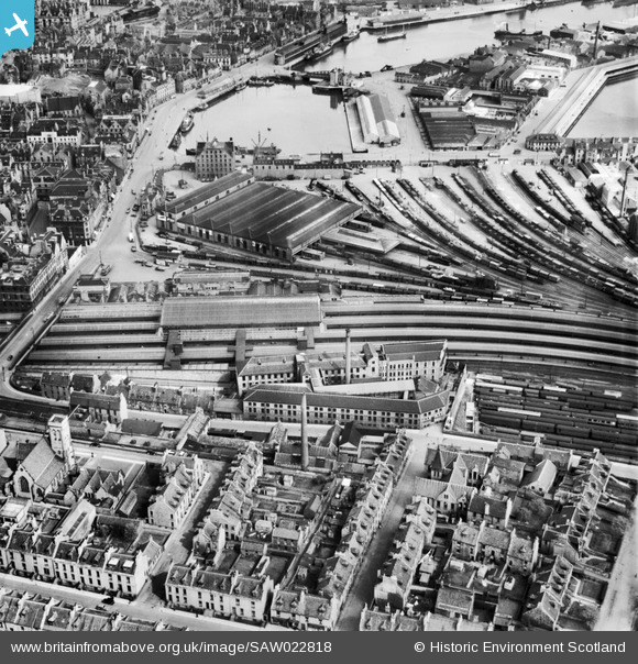
SAW022818 SCOTLAND (1949). Aberdeen, general view, showing Wiggins Teape Ltd. Pirie Appleton and Co. Paper Mills, College Street and Upper Dock. An oblique aerial photograph taken facing north-east.
© Copyright OpenStreetMap contributors and licensed by the OpenStreetMap Foundation. 2026. Cartography is licensed as CC BY-SA.
Nearby Images (20)
Details
| Title | [SAW022818] Aberdeen, general view, showing Wiggins Teape Ltd. Pirie Appleton and Co. Paper Mills, College Street and Upper Dock. An oblique aerial photograph taken facing north-east. |
| Reference | SAW022818 |
| Date | 1949 |
| Link | NRHE Collection item 1269222 |
| Place name | |
| Parish | ABERDEEN |
| District | CITY OF ABERDEEN |
| Country | SCOTLAND |
| Easting / Northing | 394100, 805870 |
| Longitude / Latitude | -2.0975087724175, 57.143868891469 |
| National Grid Reference | NJ941059 |
Pins

John Wass |
Friday 18th of July 2014 08:08:09 PM |


![[SAW022818] Aberdeen, general view, showing Wiggins Teape Ltd. Pirie Appleton and Co. Paper Mills, College Street and Upper Dock. An oblique aerial photograph taken facing north-east.](http://britainfromabove.org.uk/sites/all/libraries/aerofilms-images/public/100x100/SAW/022/SAW022818.jpg)
![[SAW022822] Aberdeen, general view, showing Wiggins Teape Ltd. Pirie Appleton and Co. Paper Mills, College Street and Aberdeen Joint Railway Station. An oblique aerial photograph taken facing north-east. This image has been produced from a crop marked n](http://britainfromabove.org.uk/sites/all/libraries/aerofilms-images/public/100x100/SAW/022/SAW022822.jpg)
![[SAW022827] Aberdeen, general view, showing Wiggins Teape Ltd. Pirie Appleton and Co. Paper Mills, College Street and Upper Dock. An oblique aerial photograph taken facing north-east.](http://britainfromabove.org.uk/sites/all/libraries/aerofilms-images/public/100x100/SAW/022/SAW022827.jpg)
![[SAW022821] Aberdeen, general view, showing Wiggins Teape Ltd. Pirie Appleton and Co. Paper Mills, College Street and Aberdeen Joint Railway Station. An oblique aerial photograph taken facing north.](http://britainfromabove.org.uk/sites/all/libraries/aerofilms-images/public/100x100/SAW/022/SAW022821.jpg)
![[SAW022819] Aberdeen, general view, showing Wiggins Teape Ltd. Pirie Appleton and Co. Paper Mills, College Street and Aberdeen Joint Railway Station. An oblique aerial photograph taken facing east.](http://britainfromabove.org.uk/sites/all/libraries/aerofilms-images/public/100x100/SAW/022/SAW022819.jpg)
![[SAW022820] Wiggins Teape Ltd. Pirie Appleton and Co. Paper Mills, College Street and Aberdeen Joint Railway Station, Aberdeen. An oblique aerial photograph taken facing east.](http://britainfromabove.org.uk/sites/all/libraries/aerofilms-images/public/100x100/SAW/022/SAW022820.jpg)
![[SAW022825] Aberdeen, general view, showing Wiggins Teape Ltd. Pirie Appleton and Co. Paper Mills, College Street and Springbank Terrace. An oblique aerial photograph taken facing south-west.](http://britainfromabove.org.uk/sites/all/libraries/aerofilms-images/public/100x100/SAW/022/SAW022825.jpg)
![[SAW022826] Wiggins Teape Ltd. Pirie Appleton and Co. Paper Mills, College Street and Aberdeen Joint Railway Station, Aberdeen. An oblique aerial photograph taken facing south-east.](http://britainfromabove.org.uk/sites/all/libraries/aerofilms-images/public/100x100/SAW/022/SAW022826.jpg)
![[SPW060043] Aberdeen, general view, showing Aberdeen Station and Kirk of St Nicholas, Union Street. An oblique aerial photograph taken facing north.](http://britainfromabove.org.uk/sites/all/libraries/aerofilms-images/public/100x100/SPW/060/SPW060043.jpg)
![[SAW022823] Aberdeen, general view, showing Wiggins Teape Ltd. Pirie Appleton and Co. Paper Mills, College Street and Springbank Terrace. An oblique aerial photograph taken facing south-west.](http://britainfromabove.org.uk/sites/all/libraries/aerofilms-images/public/100x100/SAW/022/SAW022823.jpg)
![[SAW022824] Aberdeen, general view, showing Wiggins Teape Ltd. Pirie Appleton and Co. Paper Mills, College Street and Crown Street. An oblique aerial photograph taken facing south.](http://britainfromabove.org.uk/sites/all/libraries/aerofilms-images/public/100x100/SAW/022/SAW022824.jpg)
![[SAW014809] Aberdeen, general view, showing Union Terrace Gardens and Kirk of St Nicholas, Union Street. An oblique aerial photograph taken facing north-east. This image has been produced from a print.](http://britainfromabove.org.uk/sites/all/libraries/aerofilms-images/public/100x100/SAW/014/SAW014809.jpg)
![[SAW019610] Aberdeen, general view, showing Union Street and University of Aberdeen Marischal College. An oblique aerial photograph taken facing north-east. This image has been produced from a print.](http://britainfromabove.org.uk/sites/all/libraries/aerofilms-images/public/100x100/SAW/019/SAW019610.jpg)
![[SAW022562] Aberdeen, general view, showing Waverley Hotel, Guild Street and Kirk of St Nicholas, Union Street. An oblique aerial photograph taken facing north.](http://britainfromabove.org.uk/sites/all/libraries/aerofilms-images/public/100x100/SAW/022/SAW022562.jpg)
![[SAW022561] Aberdeen, general view, showing Waverley Hotel, Guild Street and Upper Dock. An oblique aerial photograph taken facing east.](http://britainfromabove.org.uk/sites/all/libraries/aerofilms-images/public/100x100/SAW/022/SAW022561.jpg)
![[SAW022560] Aberdeen, general view, showing Waverley Hotel, Guild Street and Aberdeen Market. An oblique aerial photograph taken facing north.](http://britainfromabove.org.uk/sites/all/libraries/aerofilms-images/public/100x100/SAW/022/SAW022560.jpg)
![[SAW022564] Aberdeen, general view, showing Waverley Hotel, Guild Street and Market Street. An oblique aerial photograph taken facing north-east.](http://britainfromabove.org.uk/sites/all/libraries/aerofilms-images/public/100x100/SAW/022/SAW022564.jpg)
![[SAW022563] Aberdeen, general view, showing Waverley Hotel, Guild Street and Aberdeen Market. An oblique aerial photograph taken facing north.](http://britainfromabove.org.uk/sites/all/libraries/aerofilms-images/public/100x100/SAW/022/SAW022563.jpg)
![[SAW022558] Aberdeen, general view, showing Waverley Hotel, Guild Street and Kirk of St Nicholas, Union Street. An oblique aerial photograph taken facing north. This image has been produced from a crop marked negative.](http://britainfromabove.org.uk/sites/all/libraries/aerofilms-images/public/100x100/SAW/022/SAW022558.jpg)
![[SAW022552] Aberdeen, general view, showing Douglas Hotel, Market Street and Upper Dock. An oblique aerial photograph taken facing east. This image has been produced from a crop marked negative.](http://britainfromabove.org.uk/sites/all/libraries/aerofilms-images/public/100x100/SAW/022/SAW022552.jpg)