
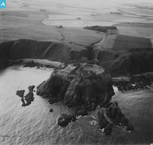
SAW019645 SCOTLAND (1948). Dunnottar Castle. An oblique aerial photograph taken facing west. This image has been produced from a print.

© Copyright OpenStreetMap contributors and licensed by the OpenStreetMap Foundation. 2026. Cartography is licensed as CC BY-SA.
Nearby Images (5)
SAW019524

SAW019645

SPW040489

SAW019523

SAW019525

Details
| Title | [SAW019645] Dunnottar Castle. An oblique aerial photograph taken facing west. This image has been produced from a print. |
| Reference | SAW019645 |
| Date | 1948 |
| Link | NRHE Collection item 1315012 |
| Place name | |
| Parish | DUNNOTTAR |
| District | KINCARDINE AND DEESIDE |
| Country | SCOTLAND |
| Easting / Northing | 388169, 783880 |
| Longitude / Latitude | -2.1944942239193, 56.946192315517 |
| National Grid Reference | NO882839 |
Pins

1st Stonehaven Cowie Airscouts |
Monday 6th of January 2014 11:54:08 AM | |
|
1st Stonehaven Cowie Airscouts |
Monday 6th of January 2014 11:53:45 AM |
User Comment Contributions
An unusual view of Dunnottar Castle. |
Brian Wilkinson |
Monday 25th of November 2013 03:06:19 PM |