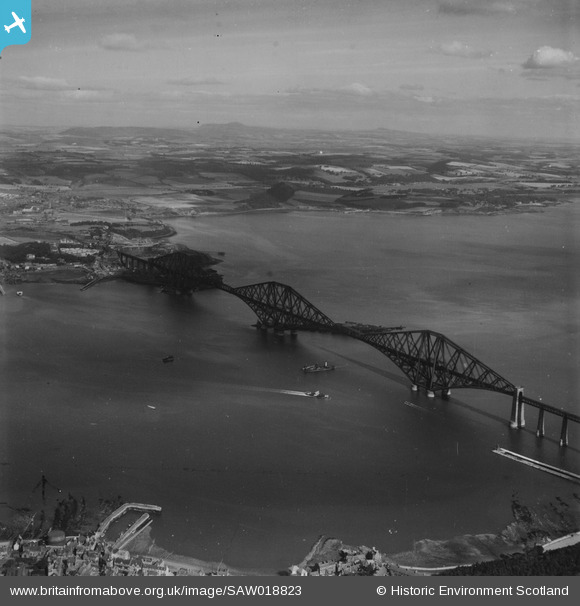
SAW018823 SCOTLAND (1948). Forth Rail Bridge and Inverkeithing Bay, Firth of Forth. An oblique aerial photograph taken facing north. This image has been produced from a print.
© Copyright OpenStreetMap contributors and licensed by the OpenStreetMap Foundation. 2026. Cartography is licensed as CC BY-SA.
Nearby Images (14)
Details
| Title | [SAW018823] Forth Rail Bridge and Inverkeithing Bay, Firth of Forth. An oblique aerial photograph taken facing north. This image has been produced from a print. |
| Reference | SAW018823 |
| Date | 1948 |
| Link | NRHE Collection item 1314873 |
| Place name | |
| Parish | DALMENY |
| District | CITY OF EDINBURGH |
| Country | SCOTLAND |
| Easting / Northing | 313554, 679252 |
| Longitude / Latitude | -3.3861974215121, 55.99846462636 |
| National Grid Reference | NT136793 |
Pins

DavidC |
Monday 27th of February 2023 09:53:44 PM | |

Billy Turner |
Wednesday 21st of December 2016 03:57:28 PM | |

Andy A |
Thursday 2nd of January 2014 06:20:13 PM | |

MB |
Monday 9th of December 2013 10:35:43 PM | |
this is either "Queen Margaret" or "Robert the Bruce" if this photo is 1948. The third ferry ("Dundee") had a single large funnel. |

Andy A |
Thursday 2nd of January 2014 06:19:22 PM |

MB |
Monday 9th of December 2013 10:35:10 PM |


![[SAR011167] Forth Bridge Dalmeny, West Lothian, Scotland. An oblique aerial photograph taken facing North/West. This image was marked by AeroPictorial Ltd for photo editing.](http://britainfromabove.org.uk/sites/all/libraries/aerofilms-images/public/100x100/SAR/011/SAR011167.jpg)
![[SAR014787] Forth Bridge from North/East Inverkeithing, Fife, Scotland. An oblique aerial photograph taken facing South/West. This image was marked by AeroPictorial Ltd for photo editing.](http://britainfromabove.org.uk/sites/all/libraries/aerofilms-images/public/100x100/SAR/014/SAR014787.jpg)
![[SAR014788] Forth Bridge from South/West Dalmeny, West Lothian, Scotland. An oblique aerial photograph taken facing North/East. This image was marked by AeroPictorial Ltd for photo editing.](http://britainfromabove.org.uk/sites/all/libraries/aerofilms-images/public/100x100/SAR/014/SAR014788.jpg)
![[SAR018711] Forth Bridge Dalmeny, West Lothian, Scotland. An oblique aerial photograph taken facing North/East.](http://britainfromabove.org.uk/sites/all/libraries/aerofilms-images/public/100x100/SAR/018/SAR018711.jpg)
![[SAW018823] Forth Rail Bridge and Inverkeithing Bay, Firth of Forth. An oblique aerial photograph taken facing north. This image has been produced from a print.](http://britainfromabove.org.uk/sites/all/libraries/aerofilms-images/public/100x100/SAW/018/SAW018823.jpg)
![[SAW018825] Firth of Forth, general view, showing Dalmeny and Forth Rail Bridge. An oblique aerial photograph taken facing north. This image has been produced from a print.](http://britainfromabove.org.uk/sites/all/libraries/aerofilms-images/public/100x100/SAW/018/SAW018825.jpg)
![[SAW036197] Forth Rail Bridge and North Queensferry, Firth of Forth. An oblique aerial photograph taken facing north. This image has been produced from a print.](http://britainfromabove.org.uk/sites/all/libraries/aerofilms-images/public/100x100/SAW/036/SAW036197.jpg)
![[SAW036198] Forth Rail Bridge and Inchcolm, Firth of Forth. An oblique aerial photograph taken facing east. This image has been produced from a print.](http://britainfromabove.org.uk/sites/all/libraries/aerofilms-images/public/100x100/SAW/036/SAW036198.jpg)
![[SAW052276] Forth Rail Bridge and Dalmeny Park, Firth of Forth. An oblique aerial photograph taken facing west. This image has been produced from a print.](http://britainfromabove.org.uk/sites/all/libraries/aerofilms-images/public/100x100/SAW/052/SAW052276.jpg)
![[SAW010716] Firth of Forth, general view, showing Queensferry and Forth Rail Bridge. An oblique aerial photograph taken facing north.](http://britainfromabove.org.uk/sites/all/libraries/aerofilms-images/public/100x100/SAW/010/SAW010716.jpg)
![[SPW054710] Forth Rail Bridge and Inch Garvie, Firth of Forth. An oblique aerial photograph taken facing south-west.](http://britainfromabove.org.uk/sites/all/libraries/aerofilms-images/public/100x100/SPW/054/SPW054710.jpg)
![[SPW054711] Firth of Forth, general view, showing Forth Rail Bridge and North Queensferry. An oblique aerial photograph taken facing south.](http://britainfromabove.org.uk/sites/all/libraries/aerofilms-images/public/100x100/SPW/054/SPW054711.jpg)
![[SPW054712] Firth of Forth, general view, showing Forth Rail Bridge and North Queensferry. An oblique aerial photograph taken facing south.](http://britainfromabove.org.uk/sites/all/libraries/aerofilms-images/public/100x100/SPW/054/SPW054712.jpg)
![[SAW018824] Forth Rail Bridge and Inchcolm, Firth of Forth. An oblique aerial photograph taken facing east. This image has been produced from a print.](http://britainfromabove.org.uk/sites/all/libraries/aerofilms-images/public/100x100/SAW/018/SAW018824.jpg)


