
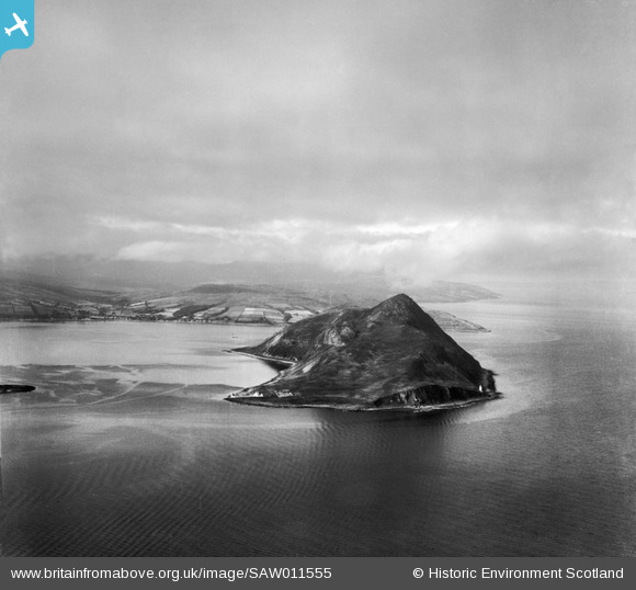
SAW011555 SCOTLAND (1947). Holy Island, general view, showing Inner Lighthouse and Mullach Mor. An oblique aerial photograph taken facing north.
© Copyright OpenStreetMap contributors and licensed by the OpenStreetMap Foundation. 2026. Cartography is licensed as CC BY-SA.
Details
| Title | [SAW011555] Holy Island, general view, showing Inner Lighthouse and Mullach Mor. An oblique aerial photograph taken facing north. |
| Reference | SAW011555 |
| Date | 1947 |
| Link | NRHE Collection item 1268773 |
| Place name | |
| Parish | KILBRIDE |
| District | CUNNINGHAME |
| Country | SCOTLAND |
| Easting / Northing | 205300, 630310 |
| Longitude / Latitude | -5.0851217349622, 55.527610280918 |
| National Grid Reference | NS053303 |
Pins

almoffat |
Friday 29th of June 2012 09:30:34 PM | |
|
almoffat |
Friday 29th of June 2012 09:26:37 PM | |
|
almoffat |
Friday 29th of June 2012 09:21:42 PM | |
|
almoffat |
Friday 29th of June 2012 09:18:41 PM | |
|
almoffat |
Friday 29th of June 2012 09:16:56 PM | |
|
almoffat |
Friday 29th of June 2012 09:16:07 PM | |
|
almoffat |
Friday 29th of June 2012 09:13:53 PM | |
|
almoffat |
Friday 29th of June 2012 09:10:39 PM |
User Comment Contributions

There is a perfect tranquility about this shot and a real sense of atmosphere with a good cloud scape. The light picking out the settlements on the island evokes the idea of a destination to a magical place and the island form itself is neatly framed. |

Oliver Brookes |
Thursday 21st of March 2013 02:21:37 PM |

Here's a recent photo of the "Inner Lighthouse" on Holy Isle the Lightkeepers Houses are now a Buddhist retreat - you can see a Monk "contemplating" at the foot of the lighthouse!! |
almoffat |
Tuesday 17th of July 2012 08:43:29 PM |
|
Is there a lighthouse on Holy Island? |

Gazgirl |
Monday 16th of July 2012 03:02:10 PM |
|
Holy Island with Arran in the background. |
Brian Wilkinson |
Friday 25th of May 2012 03:56:52 PM |