3 or 4 older (pre- Victorian?) buildings which, at the time this photograph was taken, housed Bissett (Haberdasher and Wool), a Bootmaker and Penman's (Grocer). All were demolished and replaced by flats around the mid 1970s. Penman's may have been Number 219 north High Street. |

observer |
Monday 5th of April 2021 12:06:15 PM |
Pye family, circa 1960, and Austin 16 |
wjp |
Friday 4th of October 2019 02:56:13 PM |
Older properties (ie pre-Victorian), one of which was Penman's the grocer in the 1950s. Subsequently demolished and redeveloped as flats. Penman's might have been Number 219 North High Street and adjoining properties included Bissett's (Haberdasher and Wool shop), a shoe maker/repairer and a "General Dealer"? |
observer |
Tuesday 30th of October 2018 08:28:01 PM |
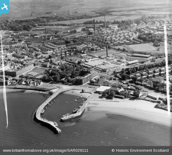
This site, now a Filling Station, was at one time - mid 19th century - a railway and/or tram depot. It is marked "Fisherrow Depot" on the 1:1056 large scale town plan of Musselburgh surveyed in 1853. It was be the site of a depot originally operated by the Edinburgh and Dalkeith Railway, which had run a branch line to the harbour in or around 1831. The light-toned curved path? appears to mark the line of a former rail or tram track.
I believe that the site was originally called "Fisherrow Station" and may have carried both passenger and freight traffic until it closed in or around 1847, when the North British Railway built a new branch line and a new station next to the "Roman Bridge". |
observer |
Tuesday 7th of February 2017 07:10:45 PM |
Approximate location of former "Belfield" (sometimes shown on maps with one "l", sometimes with two) opposite the row of houses forming the aptly-named "Bellfield Avenue". Like "Olive Bank", the house is still shown on the 1938 O.S. revision. |
observer |
Saturday 17th of January 2015 08:06:17 PM |
The approximate location of the former house named "Olive Bank", which still appears on the 1938 revision of the relevant six inch O.S.sheet. Demolished in the 1940s? |
observer |
Saturday 17th of January 2015 07:16:49 PM |
The approximate location of the former Olive Bank Colliery operated in or around the first decade of the 20th Century by the Niddrie and Benhar Coal Company. The colliery was abandoned due to problems with flooding of the workings. The chimney may have been that of the colliery. |
observer |
Saturday 17th of January 2015 06:56:01 PM |
Former "(East)Bush House" - Fisherrow Yacht Club premises from around 1957 to date. |
observer |
Sunday 30th of November 2014 03:00:22 PM |
I think that this is (the rear of) the original "Campie House" which still stood in the 1950s (in what is now "Campie Gardens")and was use as emergency? housing. It is marked as a "Convalescent Home" on the 1893 Ordnance Survey town plan. It was subsequently demolished and replaced by modern housing. Campie School was built in what had been part of its grounds.
For a 19th? century photograph of the frontage of the house, see: canmore.rcahms.gov.uk |
observer |
Sunday 30th of November 2014 02:55:32 PM |
This looks like a flatbed railway wagon on the short section of spur track which left the Musselburgh branch line and originally ran to the Harbour. if I remember correctly, there were some signs e.g.rails? still visible in the early 1950s, where this spur had crossed the main road to reach the Harbour. The ine was originally a branch (opened 1831 to carry coal) of the (horse-drawn) Edinburgh & Dalkeith Railway. |
observer |
Sunday 30th of November 2014 02:52:51 PM |
Musselburgh branch railway line, opened by the North British Railway company in 1847. |
observer |
Sunday 30th of November 2014 01:47:17 PM |
Musselburgh Railway Station which closed in the early 1960s. |
observer |
Sunday 30th of November 2014 01:45:33 PM |
Area of open, undeveloped ground (used as an informal playground) between Mitchell Street, West Holmes Gardens and Belfield Avenue. The last-mentioned street was effectively a short cul-de-sac, as can be seen here. Like "Campie House", "Belfield" and "Olive Bank" had been the names of older houses in the vicinity, whose substantial open garden grounds were subsequently developed. |
observer |
Sunday 30th of November 2014 01:33:47 PM |
Crudens office and site. The firm appears to have started in the mid-1940s as a timber merchant then building firm. Harry Cruden seems to have had an interesting life, having lived in Kenya and China! in the inter-war years. |
observer |
Sunday 30th of November 2014 01:30:41 PM |
Site of "Castle Gordon", onetime private lunatic asylum. Some ruined remains still stood in the 1950s. The site was subsequently redeveloped as flats |
observer |
Saturday 29th of November 2014 07:34:32 PM |
Onetime "Pit Cottage" - demolished and now the site of an architecturally adventurous villa. Art Deco comes to the Promenade? |
observer |
Friday 21st of November 2014 08:54:16 PM |
Lock-up garages which were entered from Market Street via two large green gates. |
observer |
Thursday 20th of November 2014 09:34:39 PM |
Salvation Army Church Hall |
observer |
Thursday 20th of November 2014 09:28:11 PM |
Part of early 'Fifties housing redevelopment of Watts Close by Musselburgh Town Council. |
observer |
Thursday 20th of November 2014 09:26:16 PM |
Redeveopment( flats- circa 1950-53 by Musselburgh Town Council) of site of former tenement called "Scrap Castle" (possibly built from re-claimed stonework?) part of the redevelopment of the south side of Market Street. |
observer |
Thursday 20th of November 2014 08:59:39 PM |
Further to my earlier post, I think that this is Hall Brothers new (ie in 1957) car showroom. They were BMC dealers, selling Austin and Morris cars and I first saw a Mini in this showroom in or around 1959. The showroom itself is long gone. |
observer |
Thursday 20th of November 2014 01:32:14 PM |
Wilson's Market Garden before it was developed for housing in the very late 'Fifties or early 'Sixties. At one time,the family also had a fruiterer/florist's shop at the corner of North High Street and Fishers Wynd. |
observer |
Thursday 20th of November 2014 01:29:23 PM |
Public Lavatory - since replaced by a less basic one. |
observer |
Thursday 23rd of October 2014 02:58:37 PM |
Fishing nets drying on the sunny Promenade |
observer |
Sunday 12th of October 2014 06:17:40 PM |
Hall Brothers garage before the new showroom was built, circa 1958/59?, to the west of Harbour Road |
observer |
Friday 26th of September 2014 08:44:20 PM |
Bogle Hole |
observer |
Saturday 13th of September 2014 07:14:31 PM |
I think this was originally named "Mollendo House", a onetime lunatic asylum and possibly later called "The Elms" |
observer |
Saturday 13th of September 2014 07:09:53 PM |
"Spring Gardens" demolished in or around the early 1960s and a storage shed (now itself gone) built on the site |
observer |
Saturday 13th of September 2014 07:05:14 PM |
The garden of "Spring Bank", which is now the M&F Welfare Club |
observer |
Saturday 13th of September 2014 07:01:33 PM |
Mitchell Street tenements |
observer |
Friday 12th of September 2014 07:58:52 PM |
Site of onetime M&F Co-op Creamery until early 'Fifties, then subsequently C0-op garage |
observer |
Friday 12th of September 2014 07:56:48 PM |
Fisherrow Primary School before it closed, as a school, in 1958. |
observer |
Wednesday 10th of September 2014 09:49:27 PM |
Fishing boats - the harbour used to be full of them |
observer |
Wednesday 10th of September 2014 09:44:28 PM |
Stoneyhill Institute/Community Centre |
observer |
Wednesday 10th of September 2014 09:42:04 PM |
Olive Bank football pitch |
observer |
Wednesday 10th of September 2014 09:33:53 PM |
Campie Primary School |
observer |
Wednesday 10th of September 2014 09:32:35 PM |
Inveresk Copper Cable mill |
Pete65 |
Tuesday 9th of September 2014 06:37:25 AM |
Fisherrow Harbour |
Pete65 |
Tuesday 9th of September 2014 06:36:51 AM |