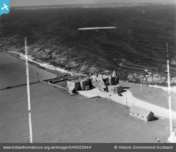
SAR023944 SCOTLAND (1955). John o' Groat's Hotel Canisbay, Caithness, Scotland. An oblique aerial photograph taken facing North/West. This image was marked by AeroPictorial Ltd for photo editing.
© Copyright OpenStreetMap contributors and licensed by the OpenStreetMap Foundation. 2026. Cartography is licensed as CC BY-SA.
Details
| Title | [SAR023944] John o' Groat's Hotel Canisbay, Caithness, Scotland. An oblique aerial photograph taken facing North/West. This image was marked by AeroPictorial Ltd for photo editing. |
| Reference | SAR023944 |
| Date | 1955 |
| Link | NRHE Collection item 1438429 |
| Place name | |
| Parish | CANISBAY |
| District | CAITHNESS |
| Country | SCOTLAND |
| Easting / Northing | 337960, 973280 |
| Longitude / Latitude | -3.0689517659794, 58.643314673226 |
| National Grid Reference | ND380733 |
Pins

bobmunc |
Tuesday 13th of September 2022 10:03:53 PM | |

The Laird |
Tuesday 17th of April 2018 05:46:16 PM | |

Billy Turner |
Sunday 23rd of October 2016 08:58:36 PM | |
I think that it is a photographic artefact created during an editing process rather than what looks, at first, like a sunken aircraft carrier. There's a similar phenomenon in SAR023946, at the mouth of Wick Harbour. |

The Laird |
Tuesday 17th of April 2018 07:16:08 PM |


![[SAR023943] John o' Groat's Hotel Canisbay, Caithness, Scotland. An oblique aerial photograph taken facing South.](http://britainfromabove.org.uk/sites/all/libraries/aerofilms-images/public/100x100/SAR/023/SAR023943.jpg)
![[SAR023944] John o' Groat's Hotel Canisbay, Caithness, Scotland. An oblique aerial photograph taken facing North/West. This image was marked by AeroPictorial Ltd for photo editing.](http://britainfromabove.org.uk/sites/all/libraries/aerofilms-images/public/100x100/SAR/023/SAR023944.jpg)