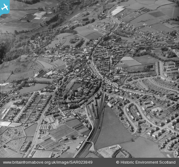
SAR023849 SCOTLAND (1955). General View Lanark, Lanarkshire, Scotland. An oblique aerial photograph taken facing North/West.
© Copyright OpenStreetMap contributors and licensed by the OpenStreetMap Foundation. 2025. Cartography is licensed as CC BY-SA.
Details
| Title | [SAR023849] General View Lanark, Lanarkshire, Scotland. An oblique aerial photograph taken facing North/West. |
| Reference | SAR023849 |
| Date | 1955 |
| Link | Canmore Collection item 1438386 |
| Place name | |
| Parish | LANARK |
| District | CLYDESDALE |
| Country | SCOTLAND |
| Easting / Northing | 287978, 643729 |
| Longitude / Latitude | -3.781468871133, 55.674120662915 |
| National Grid Reference | NS880437 |
Pins
 John Wass |
Saturday 25th of April 2015 09:25:57 PM |


![[SAR023848] General View Lanark, Lanarkshire, Scotland. An oblique aerial photograph taken facing North. This image was marked by AeroPictorial Ltd for photo editing.](http://britainfromabove.org.uk/sites/all/libraries/aerofilms-images/public/100x100/SAR/023/SAR023848.jpg)
![[SAR023849] General View Lanark, Lanarkshire, Scotland. An oblique aerial photograph taken facing North/West.](http://britainfromabove.org.uk/sites/all/libraries/aerofilms-images/public/100x100/SAR/023/SAR023849.jpg)
![[SAR023850] General View Lanark, Lanarkshire, Scotland. An oblique aerial photograph taken facing East.](http://britainfromabove.org.uk/sites/all/libraries/aerofilms-images/public/100x100/SAR/023/SAR023850.jpg)
![[SAR023851] General View Lanark, Lanarkshire, Scotland. An oblique aerial photograph taken facing North. This image was marked by AeroPictorial Ltd for photo editing.](http://britainfromabove.org.uk/sites/all/libraries/aerofilms-images/public/100x100/SAR/023/SAR023851.jpg)