
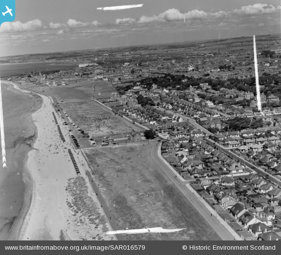
SAR016579 SCOTLAND (1952). Scottish Agricultural Industries, Saltpans Road Ayr, Ayrshire, Scotland. An oblique aerial photograph taken facing North. This image was marked by AeroPictorial Ltd for photo editing.
© Copyright OpenStreetMap contributors and licensed by the OpenStreetMap Foundation. 2025. Cartography is licensed as CC BY-SA.
Nearby Images (4)
SAR016579

SAR016580

SPW019511

SPW019516

Details
| Title | [SAR016579] Scottish Agricultural Industries, Saltpans Road Ayr, Ayrshire, Scotland. An oblique aerial photograph taken facing North. This image was marked by AeroPictorial Ltd for photo editing. |
| Reference | SAR016579 |
| Date | 1952 |
| Link | Canmore Collection item 1437921 |
| Place name | |
| Parish | AYR |
| District | KYLE AND CARRICK |
| Country | SCOTLAND |
| Easting / Northing | 233042, 621548 |
| Longitude / Latitude | -4.6408318132462, 55.459230136174 |
| National Grid Reference | NS330215 |
Pins
 Billy Turner |
Tuesday 22nd of December 2015 09:33:24 PM |

User Comment Contributions
The Scottish Agricultural Industries building is visible but it's away in the far distance on the north side of the river - the large, light-coloured building. As correctly pointed out, this photo is taken from above Seafield and shows Seafield car park, the Low Green, County Buildings and town beyond. Summer, not December! |
 Iain Foster |
Wednesday 31st of August 2016 03:55:27 PM |
I cannot believe these shots were taken in December. From the numbers of people both on the beach and in the sea, it must have been summer. Note the fabulous beach huts! |
L McInnes |
Monday 18th of January 2016 11:32:32 AM |
INCORRECT ! THIS SHOT SHOWS FROM BLACKBURN DRIVE TO THE HARBOUR VIA LOW GREEN |
rgm737 |
Wednesday 9th of December 2015 10:17:33 PM |
This photograph is wrongly titled. This is the south beach at Seafield, with Seafield Drive in the bottom right and all the buses parked in Blackburn Drive in the top center. |
tonkatoy94 |
Wednesday 12th of November 2014 02:07:45 PM |