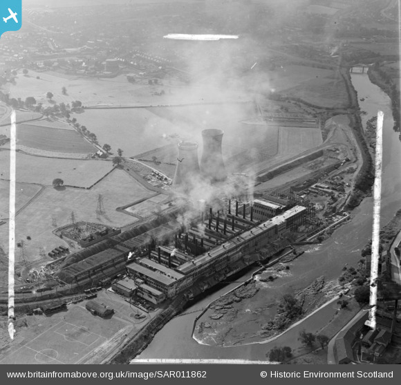
SAR011862 SCOTLAND (1949). Cambuslang Old Monkland, Lanarkshire, Scotland. An oblique aerial photograph taken facing South/West. This image was marked by AeroPictorial Ltd for photo editing.
© Copyright OpenStreetMap contributors and licensed by the OpenStreetMap Foundation. 2026. Cartography is licensed as CC BY-SA.
Nearby Images (8)
Details
| Title | [SAR011862] Cambuslang Old Monkland, Lanarkshire, Scotland. An oblique aerial photograph taken facing South/West. This image was marked by AeroPictorial Ltd for photo editing. |
| Reference | SAR011862 |
| Date | 1949 |
| Link | NRHE Collection item 1437829 |
| Place name | |
| Parish | CAMBUSLANG (CITY OF GLASGOW) |
| District | CITY OF GLASGOW |
| Country | SCOTLAND |
| Easting / Northing | 264920, 661340 |
| Longitude / Latitude | -4.1566018193086, 55.826397115294 |
| National Grid Reference | NS649613 |
Pins

Billy Turner |
Monday 6th of October 2014 05:28:08 PM |


![[SAR011861] Cambuslang Old Monkland, Lanarkshire, Scotland. An oblique aerial photograph taken facing West. This image was marked by AeroPictorial Ltd for photo editing.](http://britainfromabove.org.uk/sites/all/libraries/aerofilms-images/public/100x100/SAR/011/SAR011861.jpg)
![[SAR011862] Cambuslang Old Monkland, Lanarkshire, Scotland. An oblique aerial photograph taken facing South/West. This image was marked by AeroPictorial Ltd for photo editing.](http://britainfromabove.org.uk/sites/all/libraries/aerofilms-images/public/100x100/SAR/011/SAR011862.jpg)
![[SAR017768] BEA, Clyde Mill Generating Station Old Monkland, Lanarkshire, Scotland. An oblique aerial photograph taken facing North/East. This image was marked by AeroPictorial Ltd for photo editing.](http://britainfromabove.org.uk/sites/all/libraries/aerofilms-images/public/100x100/SAR/017/SAR017768.jpg)
![[SAR028194] South of Scotland Electricity Board, 168 Broomhill Drive Old Monkland, Lanarkshire, Scotland. An oblique aerial photograph taken facing North/East. This image was marked by AeroPictorial Ltd for photo editing.](http://britainfromabove.org.uk/sites/all/libraries/aerofilms-images/public/100x100/SAR/028/SAR028194.jpg)
![[SPW021990] Clydesmill Power Station, Cambuslang, Glasgow. An oblique aerial photograph taken facing north.](http://britainfromabove.org.uk/sites/all/libraries/aerofilms-images/public/100x100/SPW/021/SPW021990.jpg)
![[SPW021991] An oblique aerial photograph taken facing south showing Clydesmill Power Station, Cambuslang, Glasgow, in 1928.](http://britainfromabove.org.uk/sites/all/libraries/aerofilms-images/public/100x100/SPW/021/SPW021991.jpg)
![[SPW021992] Clydesmill Power Station, Cambuslang, Glasgow. An oblique aerial photograph taken facing south-west.](http://britainfromabove.org.uk/sites/all/libraries/aerofilms-images/public/100x100/SPW/021/SPW021992.jpg)
![[SPW021993] Clydesmill Power Station, Cambuslang, Glasgow. An oblique aerial photograph taken facing east.](http://britainfromabove.org.uk/sites/all/libraries/aerofilms-images/public/100x100/SPW/021/SPW021993.jpg)
