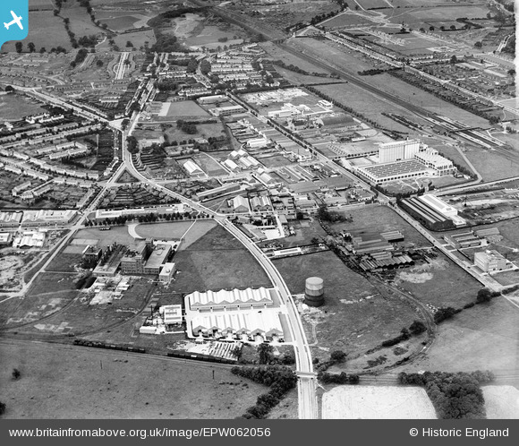
EPW062056 ENGLAND (1939). Peartree Lane and environs, Welwyn Garden City, from the north-east, 1939
© Copyright OpenStreetMap contributors and licensed by the OpenStreetMap Foundation. 2026. Cartography is licensed as CC BY-SA.
Nearby Images (18)
Details
| Title | [EPW062056] Peartree Lane and environs, Welwyn Garden City, from the north-east, 1939 |
| Reference | EPW062056 |
| Date | 28-June-1939 |
| Link | |
| Place name | WELWYN GARDEN CITY |
| Parish | |
| District | |
| Country | ENGLAND |
| Easting / Northing | 524630, 213174 |
| Longitude / Latitude | -0.19225917443137, 51.802851936207 |
| National Grid Reference | TL246132 |
Pins

Matt Aldred edob.mattaldred.com |
Thursday 7th of March 2024 11:05:18 AM | |

Matt Aldred edob.mattaldred.com |
Thursday 7th of March 2024 11:04:51 AM | |

Matt Aldred edob.mattaldred.com |
Thursday 7th of March 2024 11:04:20 AM | |

Matt Aldred edob.mattaldred.com |
Thursday 7th of March 2024 11:03:21 AM |


![[EPW062056] Peartree Lane and environs, Welwyn Garden City, from the north-east, 1939](http://britainfromabove.org.uk/sites/all/libraries/aerofilms-images/public/100x100/EPW/062/EPW062056.jpg)
![[EPW054503] Sectional Factory Units, Welwyn Garden City, 1937. This image has been affected by flare.](http://britainfromabove.org.uk/sites/all/libraries/aerofilms-images/public/100x100/EPW/054/EPW054503.jpg)
![[EAW016528] Bridge Road and the Norton Grinding Wheel Co Ltd Works (site of), Welwyn Garden City, 1948. This image has been produced from a damaged negative.](http://britainfromabove.org.uk/sites/all/libraries/aerofilms-images/public/100x100/EAW/016/EAW016528.jpg)
![[EAW016532] The Norton Grinding Wheel Co Ltd Works (site of), Welwyn Garden City, 1948. This image has been produced from a damaged negative.](http://britainfromabove.org.uk/sites/all/libraries/aerofilms-images/public/100x100/EAW/016/EAW016532.jpg)
![[EAW016526] The Sectional Factories and Norton Grinding Wheel Co Ltd Works, Welwyn Garden City, 1948. This image has been produced from a print.](http://britainfromabove.org.uk/sites/all/libraries/aerofilms-images/public/100x100/EAW/016/EAW016526.jpg)
![[EAW016535] The Norton Grinding Wheel Co Ltd Works (site of), Welwyn Garden City, 1948. This image has been produced from a damaged negative.](http://britainfromabove.org.uk/sites/all/libraries/aerofilms-images/public/100x100/EAW/016/EAW016535.jpg)
![[EAW016527] The Norton Grinding Wheel Co Ltd Works (site of), Welwyn Garden City, 1948. This image has been produced from a damaged negative.](http://britainfromabove.org.uk/sites/all/libraries/aerofilms-images/public/100x100/EAW/016/EAW016527.jpg)
![[EAW052994] The Norton Grinding Wheel Co Ltd Works, Welwyn Garden City, 1953](http://britainfromabove.org.uk/sites/all/libraries/aerofilms-images/public/100x100/EAW/052/EAW052994.jpg)
![[EAW016529] Bridge Road and the Norton Grinding Wheel Co Ltd Works (site of), Welwyn Garden City, 1948. This image has been produced from a damaged negative.](http://britainfromabove.org.uk/sites/all/libraries/aerofilms-images/public/100x100/EAW/016/EAW016529.jpg)
![[EAW016530] Bridge Road and the Norton Grinding Wheel Co Ltd Works (site of), Welwyn Garden City, 1948. This image has been produced from a damaged negative.](http://britainfromabove.org.uk/sites/all/libraries/aerofilms-images/public/100x100/EAW/016/EAW016530.jpg)
![[EAW016536] Tewin Road and the Norton Grinding Wheel Co Ltd Works (site of), Welwyn Garden City, 1948. This image has been produced from a damaged negative.](http://britainfromabove.org.uk/sites/all/libraries/aerofilms-images/public/100x100/EAW/016/EAW016536.jpg)
![[EAW016523] The Norton Grinding Wheel Co Ltd Works, Welwyn Garden City, 1948. This image has been produced from a print.](http://britainfromabove.org.uk/sites/all/libraries/aerofilms-images/public/100x100/EAW/016/EAW016523.jpg)
![[EAW053106] The Norton Grinding Wheel Co Manufactory, Welwyn Garden City, 1954](http://britainfromabove.org.uk/sites/all/libraries/aerofilms-images/public/100x100/EAW/053/EAW053106.jpg)
![[EPW054492] The Norton Grinding Wheel Co Manufactory, Welwyn Garden City, 1937](http://britainfromabove.org.uk/sites/all/libraries/aerofilms-images/public/100x100/EPW/054/EPW054492.jpg)
![[EPW047351] The Shredded Wheat Factory, other industrial works and the town, Welwyn Garden City, from the north-east, 1935](http://britainfromabove.org.uk/sites/all/libraries/aerofilms-images/public/100x100/EPW/047/EPW047351.jpg)
![[EAW016525] The Norton Grinding Wheel Co Ltd Works, Welwyn Garden City, 1948. This image has been produced from a print.](http://britainfromabove.org.uk/sites/all/libraries/aerofilms-images/public/100x100/EAW/016/EAW016525.jpg)
![[EAW016531] The Norton Grinding Wheel Co Ltd Works (site of), Welwyn Garden City, 1948. This image has been produced from a damaged negative.](http://britainfromabove.org.uk/sites/all/libraries/aerofilms-images/public/100x100/EAW/016/EAW016531.jpg)
![[EAW016533] The Norton Grinding Wheel Co Ltd Works, Welwyn Garden City, 1948. This image has been produced from a damaged negative.](http://britainfromabove.org.uk/sites/all/libraries/aerofilms-images/public/100x100/EAW/016/EAW016533.jpg)