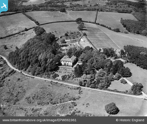
EPW061961 ENGLAND (1939). Birchwood Hall, Birchwood, 1939
© Copyright OpenStreetMap contributors and licensed by the OpenStreetMap Foundation. 2024. Cartography is licensed as CC BY-SA.
Nearby Images (6)
Details
| Title | [EPW061961] Birchwood Hall, Birchwood, 1939 |
| Reference | EPW061961 |
| Date | 8-June-1939 |
| Link | |
| Place name | BIRCHWOOD |
| Parish | CRADLEY |
| District | |
| Country | ENGLAND |
| Easting / Northing | 374947, 250144 |
| Longitude / Latitude | -2.3661846636268, 52.148605099542 |
| National Grid Reference | SO749501 |
Pins
Be the first to add a comment to this image!


![[EPW061961] Birchwood Hall, Birchwood, 1939](http://britainfromabove.org.uk/sites/all/libraries/aerofilms-images/public/100x100/EPW/061/EPW061961.jpg)
![[EPW061957] Birchwood Hall, Birchwood, 1939](http://britainfromabove.org.uk/sites/all/libraries/aerofilms-images/public/100x100/EPW/061/EPW061957.jpg)
![[EPW061958] Birchwood Hall, Birchwood, 1939](http://britainfromabove.org.uk/sites/all/libraries/aerofilms-images/public/100x100/EPW/061/EPW061958.jpg)
![[EPW061962] Birchwood Hall, Birchwood, 1939](http://britainfromabove.org.uk/sites/all/libraries/aerofilms-images/public/100x100/EPW/061/EPW061962.jpg)
![[EPW061959] Birchwood Hall, Birchwood, from the south-west, 1939. This image has been affected by flare.](http://britainfromabove.org.uk/sites/all/libraries/aerofilms-images/public/100x100/EPW/061/EPW061959.jpg)
![[EPW061960] Birchwood Hall, Birchwood, from the south, 1939](http://britainfromabove.org.uk/sites/all/libraries/aerofilms-images/public/100x100/EPW/061/EPW061960.jpg)