
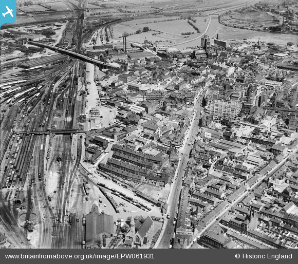
EPW061931 ENGLAND (1939). The town centre, Doncaster, 1939
© Copyright OpenStreetMap contributors and licensed by the OpenStreetMap Foundation. 2026. Cartography is licensed as CC BY-SA.
Nearby Images (7)
EPW061931

EPW061930

EPW012777

EPW012759

EPW012765

EPW012774

EPW012775

Details
| Title | [EPW061931] The town centre, Doncaster, 1939 |
| Reference | EPW061931 |
| Date | 6-July-1939 |
| Link | |
| Place name | DONCASTER |
| Parish | |
| District | |
| Country | ENGLAND |
| Easting / Northing | 457239, 403127 |
| Longitude / Latitude | -1.1365613002934, 53.521444402448 |
| National Grid Reference | SE572031 |
Pins

Ian |
Wednesday 4th of March 2015 09:21:59 PM | |
|
Ian |
Wednesday 4th of March 2015 09:13:03 PM | |
|
Ian |
Wednesday 4th of March 2015 09:08:54 PM | |
|
John Wass |
Monday 6th of October 2014 02:45:13 PM | |
|
John Wass |
Tuesday 15th of July 2014 03:18:48 PM | |
|
John Wass |
Tuesday 15th of July 2014 03:18:48 PM | |
|
John Wass |
Tuesday 24th of June 2014 08:34:13 PM | |
|
Fantasma |
Friday 14th of March 2014 10:54:49 PM | |
In 1939 this was the Great North Road, the A1. |
John Wass |
Friday 3rd of April 2015 08:22:17 PM |
|
PrioriesHistoricalSociety |
Tuesday 15th of October 2013 10:44:42 AM | |
|
PrioriesHistoricalSociety |
Tuesday 15th of October 2013 10:44:15 AM | |
And Hull, Scunthorpe and Grimsby! |
John Wass |
Monday 6th of October 2014 02:44:02 PM |
|
PrioriesHistoricalSociety |
Tuesday 15th of October 2013 10:41:33 AM | |
|
PrioriesHistoricalSociety |
Tuesday 15th of October 2013 10:41:02 AM |