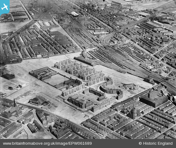
EPW061689 ENGLAND (1939). The Corporation flats and the surrounding area, Collyhurst, 1939
    © Copyright OpenStreetMap contributors and licensed by the OpenStreetMap Foundation. 2025. Cartography is licensed as CC BY-SA.
  
Nearby Images (6)
Details
| Title | [EPW061689] The Corporation flats and the surrounding area, Collyhurst, 1939 | 
| Reference | EPW061689 | 
| Date | 4-July-1939 | 
| Link | |
| Place name | COLLYHURST | 
| Parish | |
| District | |
| Country | ENGLAND | 
| Easting / Northing | 385719, 400074 | 
| Longitude / Latitude | -2.2152994455391, 53.49692330874 | 
| National Grid Reference | SD857001 | 
Pins
|  Brewery Sidings. By Barney Rubble/Laszlo Fyre. |   Barney Rubble | Friday 19th of September 2025 10:02:24 AM | 
|  Pub, The Salvage. Would become a Wilsons pub if it wasn't already. By Barney Rubble/Laszlo Fyre. |   Barney Rubble | Friday 19th of September 2025 09:59:40 AM | 
|  I think this was to become the Jonak curry takeaway in the late 70s. Had many an upset stomach and attacks of gout after partaking from there. But I would go back and do it all over again. BITD when a chicken curry had options for on/off the bone, and sometimes leg/breast. Their menu also listed 'pies and fishes' and 'fired rice'. By Barney Rubble/Laszlo Fyre, FAO Harold Horseposture. |   Barney Rubble | Monday 23rd of June 2025 03:44:09 PM | 
|  Palladium Variety Club that would become The Electric Circus music venue |   NumberThirt13n | Thursday 25th of August 2016 10:17:32 PM | 
|  Miles Platting Station. |   chadders47 | Monday 9th of May 2016 03:40:53 PM | 
|  Essoldo Cinema & War Memorial. |   chadders47 | Monday 9th of May 2016 03:38:53 PM | 
|  Wilsons (Newton Heath) Brewery. |   chadders47 | Monday 9th of May 2016 03:35:44 PM | 
|  St. Augustine's Church and School. |   chadders47 | Monday 9th of May 2016 03:35:02 PM | 
|  The Albert Memorial School. |   chadders47 | Monday 9th of May 2016 03:33:23 PM | 
|  Playhouse Cinema. |   chadders47 | Monday 9th of May 2016 03:31:55 PM | 
User Comment Contributions
| This photograph also includes Miles Platting west of Queens Road and south of Oldham Road. Newton Heath is at the top of the photograph. |   chadders47 | Monday 9th of May 2016 03:47:53 PM | 
 
             
  ![[EPW061689] The Corporation flats and the surrounding area, Collyhurst, 1939](http://britainfromabove.org.uk/sites/all/libraries/aerofilms-images/public/100x100/EPW/061/EPW061689.jpg) 
  
                                          ![[EPW061690] The Corporation flats and the surrounding area, Collyhurst, 1939](http://britainfromabove.org.uk/sites/all/libraries/aerofilms-images/public/100x100/EPW/061/EPW061690.jpg) 
 ![[EPW061686] The Corporation flats and the surrounding residential area, Collyhurst, 1939](http://britainfromabove.org.uk/sites/all/libraries/aerofilms-images/public/100x100/EPW/061/EPW061686.jpg) 
 ![[EPW061688] The Corporation flats, Collyhurst, 1939](http://britainfromabove.org.uk/sites/all/libraries/aerofilms-images/public/100x100/EPW/061/EPW061688.jpg) 
 ![[EPW061685] The Corporation flats, Queen's Park and the surrounding residential area, Collyhurst, 1939](http://britainfromabove.org.uk/sites/all/libraries/aerofilms-images/public/100x100/EPW/061/EPW061685.jpg) 
 ![[EPW061687] The Corporation flats and the surrounding residential area, Collyhurst, 1939](http://britainfromabove.org.uk/sites/all/libraries/aerofilms-images/public/100x100/EPW/061/EPW061687.jpg)