
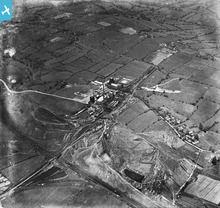
EPW061442 ENGLAND (1939). Chatterley Whitfield Colliery, Whitfield, 1939. This image has been produced from a damaged negative.

© Copyright OpenStreetMap contributors and licensed by the OpenStreetMap Foundation. 2026. Cartography is licensed as CC BY-SA.
Nearby Images (7)
EPW061442

EPW061445

EPW061439

EPW061436

EPW061443

EPW061438

EPW061440

Details
| Title | [EPW061442] Chatterley Whitfield Colliery, Whitfield, 1939. This image has been produced from a damaged negative. |
| Reference | EPW061442 |
| Date | 1-June-1939 |
| Link | |
| Place name | WHITFIELD |
| Parish | |
| District | |
| Country | ENGLAND |
| Easting / Northing | 388373, 353210 |
| Longitude / Latitude | -2.1735723817329, 53.075693380758 |
| National Grid Reference | SJ884532 |
Pins

bescotbeast |
Saturday 22nd of March 2014 04:40:02 AM | |
|
bescotbeast |
Saturday 22nd of March 2014 04:35:15 AM | |

IvanSherratt |
Sunday 29th of September 2013 10:32:59 AM | |
|
IvanSherratt |
Sunday 29th of September 2013 10:32:53 AM | |
|
IvanSherratt |
Saturday 14th of September 2013 01:09:41 AM | |
|
IvanSherratt |
Saturday 14th of September 2013 01:08:27 AM |
User Comment Contributions
Rather grainy shot of Whitfield Sidings signal box, NSR Type2 design |
bescotbeast |
Saturday 22nd of March 2014 04:36:02 AM |