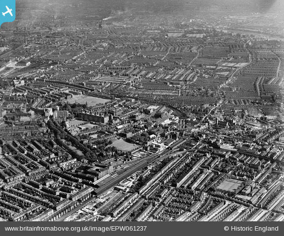
EPW061237 ENGLAND (1939). West Kensington and Fulham, Hammersmith, from the north-west, 1939
© Copyright OpenStreetMap contributors and licensed by the OpenStreetMap Foundation. 2026. Cartography is licensed as CC BY-SA.
Details
| Title | [EPW061237] West Kensington and Fulham, Hammersmith, from the north-west, 1939 |
| Reference | EPW061237 |
| Date | 26-May-1939 |
| Link | |
| Place name | HAMMERSMITH |
| Parish | |
| District | |
| Country | ENGLAND |
| Easting / Northing | 523293, 178972 |
| Longitude / Latitude | -0.22370110022947, 51.495743451534 |
| National Grid Reference | TQ233790 |
Pins

Leslie B |
Wednesday 24th of August 2022 10:40:04 PM | |

Leslie B |
Wednesday 20th of July 2022 08:54:33 PM | |

Danno |
Saturday 4th of April 2020 01:30:17 PM | |

Danno |
Saturday 4th of April 2020 01:17:38 PM | |

Leslie B |
Wednesday 18th of May 2016 08:08:04 PM | |

bondi |
Sunday 8th of November 2015 07:21:29 PM | |

designking |
Monday 8th of December 2014 08:35:10 PM | |

designking |
Sunday 28th of September 2014 10:07:39 PM | |

Class31 |
Thursday 11th of September 2014 02:57:14 PM | |

Class31 |
Thursday 11th of September 2014 02:55:58 PM | |

Class31 |
Tuesday 9th of September 2014 12:52:13 PM | |

Alan McFaden |
Tuesday 3rd of September 2013 10:08:12 AM |


![[EPW061237] West Kensington and Fulham, Hammersmith, from the north-west, 1939](http://britainfromabove.org.uk/sites/all/libraries/aerofilms-images/public/100x100/EPW/061/EPW061237.jpg)
![[EPW006183] The Osram Lamp Works, Hammersmith, 1921](http://britainfromabove.org.uk/sites/all/libraries/aerofilms-images/public/100x100/EPW/006/EPW006183.jpg)
![[EPW059943] A cityscape, Hammersmith, 1938. This image has been produced from a print.](http://britainfromabove.org.uk/sites/all/libraries/aerofilms-images/public/100x100/EPW/059/EPW059943.jpg)
![[EPW034911] Hammersmith Broadway, the Convent and School of the Sacred Heart, the West London Hospital and environs, Hammersmith, 1931](http://britainfromabove.org.uk/sites/all/libraries/aerofilms-images/public/100x100/EPW/034/EPW034911.jpg)
