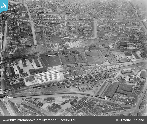
EPW061178 ENGLAND (1939). The British Timken Roller Bearing Works on Cheston Road and environs, Aston, 1939
© Copyright OpenStreetMap contributors and licensed by the OpenStreetMap Foundation. 2026. Cartography is licensed as CC BY-SA.
Nearby Images (26)
Details
| Title | [EPW061178] The British Timken Roller Bearing Works on Cheston Road and environs, Aston, 1939 |
| Reference | EPW061178 |
| Date | 26-May-1939 |
| Link | |
| Place name | ASTON |
| Parish | |
| District | |
| Country | ENGLAND |
| Easting / Northing | 408531, 288990 |
| Longitude / Latitude | -1.8743205174524, 52.498380693775 |
| National Grid Reference | SP085890 |
Pins

Graham |
Monday 2nd of April 2018 08:35:22 PM |


![[EPW061178] The British Timken Roller Bearing Works on Cheston Road and environs, Aston, 1939](http://britainfromabove.org.uk/sites/all/libraries/aerofilms-images/public/100x100/EPW/061/EPW061178.jpg)
![[EPW046036] The British Timken Ltd Roller Bearing Works, Aston, 1934](http://britainfromabove.org.uk/sites/all/libraries/aerofilms-images/public/100x100/EPW/046/EPW046036.jpg)
![[EAW045883] The British Timken Ltd Roller Bearing Works on Cheston Road and surrounding factories alongside the Birmingham and Fazeley Canal, Aston, 1952. This image was marked by Aerofilms Ltd for photo editing.](http://britainfromabove.org.uk/sites/all/libraries/aerofilms-images/public/100x100/EAW/045/EAW045883.jpg)
![[EAW045879] The British Timken Ltd Roller Bearing Works on Cheston Road and surrounding factories, Aston, 1952. This image was marked by Aerofilms Ltd for photo editing.](http://britainfromabove.org.uk/sites/all/libraries/aerofilms-images/public/100x100/EAW/045/EAW045879.jpg)
![[EPW046031] The British Timken Ltd Roller Bearing Works and other factories on Cheston Road, Aston, 1934](http://britainfromabove.org.uk/sites/all/libraries/aerofilms-images/public/100x100/EPW/046/EPW046031.jpg)
![[EAW045877] The British Timken Ltd Roller Bearing Works on Cheston Road and surrounding factories alongside the Birmingham and Fazeley Canal, Aston, 1952. This image was marked by Aerofilms Ltd for photo editing.](http://britainfromabove.org.uk/sites/all/libraries/aerofilms-images/public/100x100/EAW/045/EAW045877.jpg)
![[EAW045885] The British Timken Ltd Roller Bearing Works on Cheston Road and surrounding factories alongside the Birmingham and Fazeley Canal, Aston, 1952. This image was marked by Aerofilms Ltd for photo editing.](http://britainfromabove.org.uk/sites/all/libraries/aerofilms-images/public/100x100/EAW/045/EAW045885.jpg)
![[EPW046033] The British Timken Ltd Roller Bearing Works and other factories on Cheston Road, Aston, 1934](http://britainfromabove.org.uk/sites/all/libraries/aerofilms-images/public/100x100/EPW/046/EPW046033.jpg)
![[EAW045876] The British Timken Ltd Roller Bearing Works on Cheston Road and surrounding factories, Aston, 1952. This image was marked by Aerofilms Ltd for photo editing.](http://britainfromabove.org.uk/sites/all/libraries/aerofilms-images/public/100x100/EAW/045/EAW045876.jpg)
![[EAW045878] The British Timken Ltd Roller Bearing Works on Cheston Road and surrounding factories alongside the Birmingham and Fazeley Canal, Aston, 1952. This image was marked by Aerofilms Ltd for photo editing.](http://britainfromabove.org.uk/sites/all/libraries/aerofilms-images/public/100x100/EAW/045/EAW045878.jpg)
![[EPW046037] The British Timken Ltd Roller Bearing Works, Aston, 1934](http://britainfromabove.org.uk/sites/all/libraries/aerofilms-images/public/100x100/EPW/046/EPW046037.jpg)
![[EPW046035] The British Timken Ltd Roller Bearing Works, Aston, 1934. This image has been produced from a damaged negative.](http://britainfromabove.org.uk/sites/all/libraries/aerofilms-images/public/100x100/EPW/046/EPW046035.jpg)
![[EPW061173] The British Timken Roller Bearing Works on Cheston Road and environs, Aston, 1939](http://britainfromabove.org.uk/sites/all/libraries/aerofilms-images/public/100x100/EPW/061/EPW061173.jpg)
![[EPW046034] The British Timken Ltd Roller Bearing Works and other factories on Cheston Road, Aston, 1934](http://britainfromabove.org.uk/sites/all/libraries/aerofilms-images/public/100x100/EPW/046/EPW046034.jpg)
![[EAW045881] The British Timken Ltd Roller Bearing Works on Cheston Road and surrounding factories alongside the Birmingham and Fazeley Canal, Aston, 1952. This image was marked by Aerofilms Ltd for photo editing.](http://britainfromabove.org.uk/sites/all/libraries/aerofilms-images/public/100x100/EAW/045/EAW045881.jpg)
![[EAW045880] The British Timken Ltd Roller Bearing Works on Cheston Road and surrounding factories alongside the Birmingham and Fazeley Canal, Aston, 1952. This image was marked by Aerofilms Ltd for photo editing.](http://britainfromabove.org.uk/sites/all/libraries/aerofilms-images/public/100x100/EAW/045/EAW045880.jpg)
![[EPW061174] The British Timken Roller Bearing Works on Cheston Road and environs, Aston, 1939](http://britainfromabove.org.uk/sites/all/libraries/aerofilms-images/public/100x100/EPW/061/EPW061174.jpg)
![[EAW045882] The British Timken Ltd Roller Bearing Works on Cheston Road and surrounding factories alongside the Birmingham and Fazeley Canal, Aston, 1952. This image was marked by Aerofilms Ltd for photo editing.](http://britainfromabove.org.uk/sites/all/libraries/aerofilms-images/public/100x100/EAW/045/EAW045882.jpg)
![[EPW061175] The British Timken Roller Bearing Works on Cheston Road and environs, Aston, 1939](http://britainfromabove.org.uk/sites/all/libraries/aerofilms-images/public/100x100/EPW/061/EPW061175.jpg)
![[EPW061177] The British Timken Roller Bearing Works on Cheston Road and environs, Aston, 1939](http://britainfromabove.org.uk/sites/all/libraries/aerofilms-images/public/100x100/EPW/061/EPW061177.jpg)
![[EAW045884] The British Timken Ltd Roller Bearing Works on Cheston Road and surrounding factories alongside the Birmingham and Fazeley Canal, Aston, 1952. This image was marked by Aerofilms Ltd for photo editing.](http://britainfromabove.org.uk/sites/all/libraries/aerofilms-images/public/100x100/EAW/045/EAW045884.jpg)
![[EPW061176] The British Timken Roller Bearing Works on Cheston Road and environs, Aston, from the south-east, 1939](http://britainfromabove.org.uk/sites/all/libraries/aerofilms-images/public/100x100/EPW/061/EPW061176.jpg)
![[EPW061179] The British Timken Roller Bearing Works on Cheston Road and environs, Aston, 1939](http://britainfromabove.org.uk/sites/all/libraries/aerofilms-images/public/100x100/EPW/061/EPW061179.jpg)
![[EAW045875] The British Timken Ltd Roller Bearing Works on Cheston Road and surrounding factories, Aston, 1952. This image was marked by Aerofilms Ltd for photo editing.](http://britainfromabove.org.uk/sites/all/libraries/aerofilms-images/public/100x100/EAW/045/EAW045875.jpg)
![[EPW046038] The British Timken Ltd Roller Bearing Works, Aston, from the south-east, 1934](http://britainfromabove.org.uk/sites/all/libraries/aerofilms-images/public/100x100/EPW/046/EPW046038.jpg)
![[EPW046032] The British Timken Ltd Roller Bearing Works and other factories on Cheston Road, Aston, from the east, 1934](http://britainfromabove.org.uk/sites/all/libraries/aerofilms-images/public/100x100/EPW/046/EPW046032.jpg)