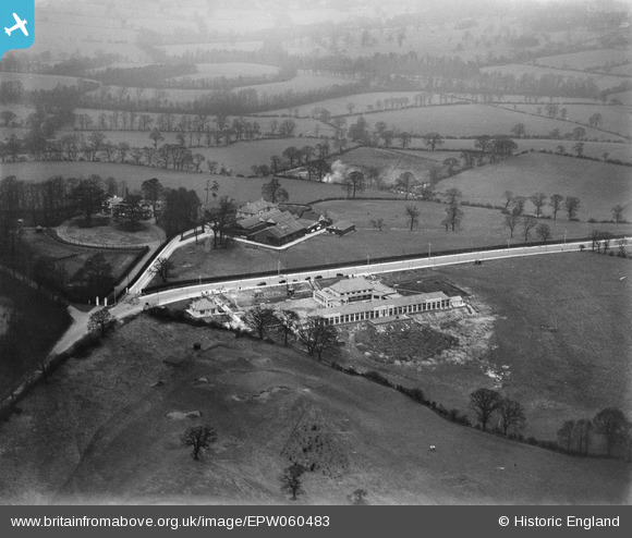
EPW060483 ENGLAND (1939). Frith Manor School under construction, Mill Hill, 1939
© Copyright OpenStreetMap contributors and licensed by the OpenStreetMap Foundation. 2025. Cartography is licensed as CC BY-SA.
Nearby Images (7)
Details
| Title | [EPW060483] Frith Manor School under construction, Mill Hill, 1939 |
| Reference | EPW060483 |
| Date | 9-February-1939 |
| Link | |
| Place name | MILL HILL |
| Parish | |
| District | |
| Country | ENGLAND |
| Easting / Northing | 524558, 192271 |
| Longitude / Latitude | -0.20077426968363, 51.614997456703 |
| National Grid Reference | TQ246923 |
Pins
Be the first to add a comment to this image!


![[EPW060483] Frith Manor School under construction, Mill Hill, 1939](http://britainfromabove.org.uk/sites/all/libraries/aerofilms-images/public/100x100/EPW/060/EPW060483.jpg)
![[EPW060485] Frith Manor School under construction, Mill Hill, 1939](http://britainfromabove.org.uk/sites/all/libraries/aerofilms-images/public/100x100/EPW/060/EPW060485.jpg)
![[EPW060489] Frith Manor School under construction, Mill Hill, 1939](http://britainfromabove.org.uk/sites/all/libraries/aerofilms-images/public/100x100/EPW/060/EPW060489.jpg)
![[EPW060482] Lullington Garth, Frith Manor and surrounding countryside, Mill Hill, from the east, 1939](http://britainfromabove.org.uk/sites/all/libraries/aerofilms-images/public/100x100/EPW/060/EPW060482.jpg)
![[EPW060493] Folkington Corner, Offham Slope, Rodmell Slope and environs, Woodside Park, 1939](http://britainfromabove.org.uk/sites/all/libraries/aerofilms-images/public/100x100/EPW/060/EPW060493.jpg)
![[EPW060487] Folkington Corner, Offham Slope and environs, Woodside Park, from the south, 1939](http://britainfromabove.org.uk/sites/all/libraries/aerofilms-images/public/100x100/EPW/060/EPW060487.jpg)
![[EPW060484] Frith Manor School under construction, Lullington Garth and environs, Mill Hill, 1939](http://britainfromabove.org.uk/sites/all/libraries/aerofilms-images/public/100x100/EPW/060/EPW060484.jpg)