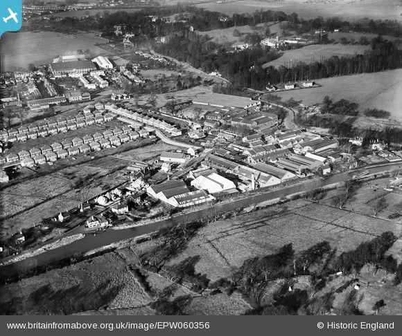
EPW060356 ENGLAND (1939). The Black Boy Works, Woburn Farm and environs, Hamm Moor, 1939
© Copyright OpenStreetMap contributors and licensed by the OpenStreetMap Foundation. 2026. Cartography is licensed as CC BY-SA.
Nearby Images (16)
Details
| Title | [EPW060356] The Black Boy Works, Woburn Farm and environs, Hamm Moor, 1939 |
| Reference | EPW060356 |
| Date | 12-January-1939 |
| Link | |
| Place name | HAMM MOOR |
| Parish | |
| District | |
| Country | ENGLAND |
| Easting / Northing | 506224, 164655 |
| Longitude / Latitude | -0.47381023402149, 51.370508010501 |
| National Grid Reference | TQ062647 |
Pins
Be the first to add a comment to this image!


![[EPW060356] The Black Boy Works, Woburn Farm and environs, Hamm Moor, 1939](http://britainfromabove.org.uk/sites/all/libraries/aerofilms-images/public/100x100/EPW/060/EPW060356.jpg)
![[EPW060355] The Black Boy Works, Woburn Farm and environs, Hamm Moor, 1939](http://britainfromabove.org.uk/sites/all/libraries/aerofilms-images/public/100x100/EPW/060/EPW060355.jpg)
![[EPW060357] The Black Boy Works, Hamm Moor, 1939](http://britainfromabove.org.uk/sites/all/libraries/aerofilms-images/public/100x100/EPW/060/EPW060357.jpg)
![[EAW034369] The Airscrew Company and Jicwood Ltd Works on Hamm Moor Lane, Hamm Moor, 1950. This image has been produced from a print marked by Aerofilms Ltd for photo editing.](http://britainfromabove.org.uk/sites/all/libraries/aerofilms-images/public/100x100/EAW/034/EAW034369.jpg)
![[EAW034372] The Airscrew Company and Jicwood Ltd Works on Hamm Moor Lane, Hamm Moor, 1950. This image has been produced from a print marked by Aerofilms Ltd for photo editing.](http://britainfromabove.org.uk/sites/all/libraries/aerofilms-images/public/100x100/EAW/034/EAW034372.jpg)
![[EPW060352] The Black Boy Works, Hamm Moor, 1939](http://britainfromabove.org.uk/sites/all/libraries/aerofilms-images/public/100x100/EPW/060/EPW060352.jpg)
![[EAW034370] The Airscrew Company and Jicwood Ltd Works on Hamm Moor Lane, Hamm Moor, 1950. This image has been produced from a print marked by Aerofilms Ltd for photo editing.](http://britainfromabove.org.uk/sites/all/libraries/aerofilms-images/public/100x100/EAW/034/EAW034370.jpg)
![[EAW034365] The Airscrew Company and Jicwood Ltd Works on Hamm Moor Lane, Hamm Moor, 1950. This image has been produced from a print marked by Aerofilms Ltd for photo editing.](http://britainfromabove.org.uk/sites/all/libraries/aerofilms-images/public/100x100/EAW/034/EAW034365.jpg)
![[EAW034371] The Airscrew Company and Jicwood Ltd Works on Hamm Moor Lane, Hamm Moor, 1950. This image has been produced from a print marked by Aerofilms Ltd for photo editing.](http://britainfromabove.org.uk/sites/all/libraries/aerofilms-images/public/100x100/EAW/034/EAW034371.jpg)
![[EAW034366] The Airscrew Company and Jicwood Ltd Works on Hamm Moor Lane, Hamm Moor, 1950. This image has been produced from a print marked by Aerofilms Ltd for photo editing.](http://britainfromabove.org.uk/sites/all/libraries/aerofilms-images/public/100x100/EAW/034/EAW034366.jpg)
![[EAW034367] The Airscrew Company and Jicwood Ltd Works on Hamm Moor Lane, Hamm Moor, 1950. This image has been produced from a print marked by Aerofilms Ltd for photo editing.](http://britainfromabove.org.uk/sites/all/libraries/aerofilms-images/public/100x100/EAW/034/EAW034367.jpg)
![[EAW034374] The Airscrew Company and Jicwood Ltd Works on Hamm Moor Lane, Hamm Moor, 1950. This image has been produced from a print marked by Aerofilms Ltd for photo editing.](http://britainfromabove.org.uk/sites/all/libraries/aerofilms-images/public/100x100/EAW/034/EAW034374.jpg)
![[EAW034364] The Airscrew Company and Jicwood Ltd Works on Hamm Moor Lane, Hamm Moor, 1950. This image has been produced from a print marked by Aerofilms Ltd for photo editing.](http://britainfromabove.org.uk/sites/all/libraries/aerofilms-images/public/100x100/EAW/034/EAW034364.jpg)
![[EAW034368] The Airscrew Company and Jicwood Ltd Works on Hamm Moor Lane, Hamm Moor, 1950. This image has been produced from a print marked by Aerofilms Ltd for photo editing.](http://britainfromabove.org.uk/sites/all/libraries/aerofilms-images/public/100x100/EAW/034/EAW034368.jpg)
![[EPW001524] Black Boy Works, Hamm Moor, 1920](http://britainfromabove.org.uk/sites/all/libraries/aerofilms-images/public/100x100/EPW/001/EPW001524.jpg)
![[EAW029252] Industrial buildings at the edge of the Weybridge Trading Estate off Weybridge Road, Addlestone, 1950. This image was marked by Aerofilms Ltd for photo editing.](http://britainfromabove.org.uk/sites/all/libraries/aerofilms-images/public/100x100/EAW/029/EAW029252.jpg)