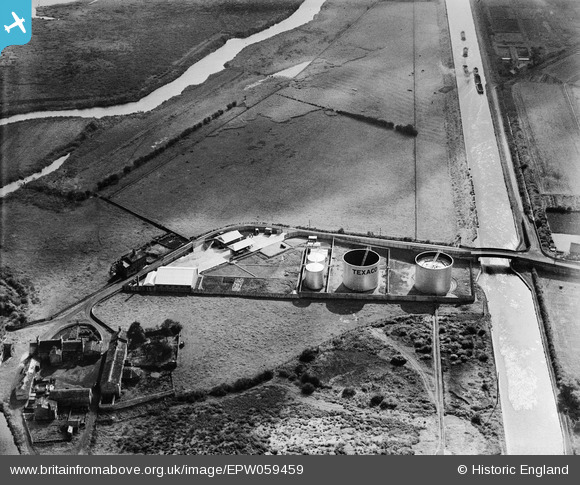
EPW059459 ENGLAND (1938). Texaco Oil Depot at Fleet Bridge, Rothwell, 1938
    © Copyright OpenStreetMap contributors and licensed by the OpenStreetMap Foundation. 2025. Cartography is licensed as CC BY-SA.
  
Details
| Title | [EPW059459] Texaco Oil Depot at Fleet Bridge, Rothwell, 1938 | 
| Reference | EPW059459 | 
| Date | 22-October-1938 | 
| Link | |
| Place name | ROTHWELL | 
| Parish | |
| District | |
| Country | ENGLAND | 
| Easting / Northing | 438070, 428344 | 
| Longitude / Latitude | -1.4226148982957, 53.749853421037 | 
| National Grid Reference | SE381283 | 
Pins
Be the first to add a comment to this image!
 
             
  ![[EPW059459] Texaco Oil Depot at Fleet Bridge, Rothwell, 1938](http://britainfromabove.org.uk/sites/all/libraries/aerofilms-images/public/100x100/EPW/059/EPW059459.jpg) 
  
                                          ![[EPW059458] Texaco Oil Depot at Fleet Bridge, Rothwell, 1938](http://britainfromabove.org.uk/sites/all/libraries/aerofilms-images/public/100x100/EPW/059/EPW059458.jpg) 
 ![[EPW059457] Texaco Oil Depot at Fleet Bridge, Rothwell, 1938](http://britainfromabove.org.uk/sites/all/libraries/aerofilms-images/public/100x100/EPW/059/EPW059457.jpg) 
 ![[EAW002532] A spoil tip surrounded by flood waters between the Aire & Calder Navigation and the River Aire, Woodlesford, from the south-east, 1946](http://britainfromabove.org.uk/sites/all/libraries/aerofilms-images/public/100x100/EAW/002/EAW002532.jpg)