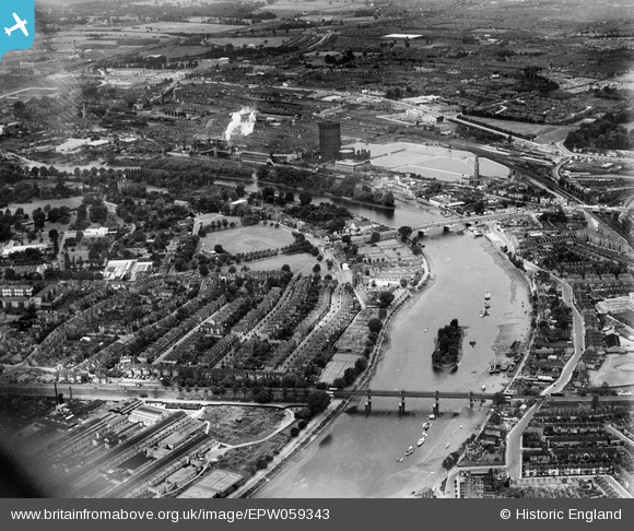
EPW059343 ENGLAND (1938). Kew Bridge, Kew Green and the Kew Bridge Water Works, Kew, 1938
    © Copyright OpenStreetMap contributors and licensed by the OpenStreetMap Foundation. 2025. Cartography is licensed as CC BY-SA.
  
Details
| Title | [EPW059343] Kew Bridge, Kew Green and the Kew Bridge Water Works, Kew, 1938 | 
| Reference | EPW059343 | 
| Date | 12-October-1938 | 
| Link | |
| Place name | KEW | 
| Parish | |
| District | |
| Country | ENGLAND | 
| Easting / Northing | 519037, 177612 | 
| Longitude / Latitude | -0.28544652886693, 51.484431479014 | 
| National Grid Reference | TQ190776 | 
 
             
  ![[EPW059343] Kew Bridge, Kew Green and the Kew Bridge Water Works, Kew, 1938](http://britainfromabove.org.uk/sites/all/libraries/aerofilms-images/public/100x100/EPW/059/EPW059343.jpg) 
  
                                          ![[EPW022565] Kew Bridge and Kew Green, Kew, 1928](http://britainfromabove.org.uk/sites/all/libraries/aerofilms-images/public/100x100/EPW/022/EPW022565.jpg) 
 ![[EAW042756] Kew Bridge (site of), Kew, 1952. This image has been produced from a damaged negative.](http://britainfromabove.org.uk/sites/all/libraries/aerofilms-images/public/100x100/EAW/042/EAW042756.jpg) 
 ![[EPW057062] Kew Bridge and Strand-on-the-Green, Gunnersbury, from the south-west, 1938](http://britainfromabove.org.uk/sites/all/libraries/aerofilms-images/public/100x100/EPW/057/EPW057062.jpg) 
  The Express Tavern. It was a Benskin's of Watford house at this time.
 The Express Tavern. It was a Benskin's of Watford house at this time.