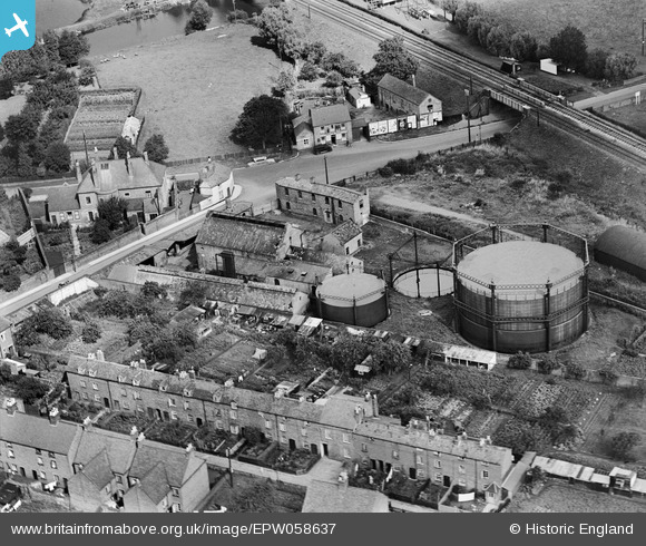
EPW058637 ENGLAND (1938). Gas Works adjacent to the Ashchurch, Tewkesbury and Malvern Branch Line and environs, Tewkesbury, 1938
© Copyright OpenStreetMap contributors and licensed by the OpenStreetMap Foundation. 2026. Cartography is licensed as CC BY-SA.
Nearby Images (10)
Details
| Title | [EPW058637] Gas Works adjacent to the Ashchurch, Tewkesbury and Malvern Branch Line and environs, Tewkesbury, 1938 |
| Reference | EPW058637 |
| Date | 13-August-1938 |
| Link | |
| Place name | TEWKESBURY |
| Parish | TEWKESBURY |
| District | |
| Country | ENGLAND |
| Easting / Northing | 389572, 233225 |
| Longitude / Latitude | -2.1519040456188, 51.996946188821 |
| National Grid Reference | SO896332 |
Pins

Toby Clempson |
Sunday 2nd of March 2014 05:26:06 PM | |

Toby Clempson |
Sunday 2nd of March 2014 05:25:01 PM | |

Toby Clempson |
Sunday 2nd of March 2014 05:24:35 PM | |

Toby Clempson |
Sunday 2nd of March 2014 05:23:53 PM | |

MB |
Sunday 16th of June 2013 11:24:16 AM | |

MB |
Sunday 16th of June 2013 11:22:56 AM | |

MB |
Sunday 16th of June 2013 11:22:42 AM | |

MB |
Sunday 16th of June 2013 11:22:07 AM | |

MB |
Sunday 16th of June 2013 11:20:54 AM | |

MB |
Sunday 16th of June 2013 11:20:37 AM |


![[EPW058637] Gas Works adjacent to the Ashchurch, Tewkesbury and Malvern Branch Line and environs, Tewkesbury, 1938](http://britainfromabove.org.uk/sites/all/libraries/aerofilms-images/public/100x100/EPW/058/EPW058637.jpg)
![[EPW058636] Gas Works adjacent to the Ashchurch, Tewkesbury and Malvern Branch Line and environs, Tewkesbury, 1938](http://britainfromabove.org.uk/sites/all/libraries/aerofilms-images/public/100x100/EPW/058/EPW058636.jpg)
![[EPW058635] Gas Works adjacent to the Ashchurch, Tewkesbury and Malvern Branch Line and environs, Tewkesbury, 1938](http://britainfromabove.org.uk/sites/all/libraries/aerofilms-images/public/100x100/EPW/058/EPW058635.jpg)
![[EPW058633] Gas Works adjacent to the Ashchurch, Tewkesbury and Malvern Branch Line and environs, Tewkesbury, 1938](http://britainfromabove.org.uk/sites/all/libraries/aerofilms-images/public/100x100/EPW/058/EPW058633.jpg)
![[EPW058634] Gas Works adjacent to the Ashchurch, Tewkesbury and Malvern Branch Line, Tewkesbury, 1938](http://britainfromabove.org.uk/sites/all/libraries/aerofilms-images/public/100x100/EPW/058/EPW058634.jpg)
![[EPW023939] The Police Station and Bredon Road Railway Bridge, Tewkesbury, 1928](http://britainfromabove.org.uk/sites/all/libraries/aerofilms-images/public/100x100/EPW/023/EPW023939.jpg)
![[EPW058632] Gas Works adjacent to the Ashchurch, Tewkesbury and Malvern Branch Line, Tewkesbury, 1938](http://britainfromabove.org.uk/sites/all/libraries/aerofilms-images/public/100x100/EPW/058/EPW058632.jpg)
![[EAW049072] Stanchard Pit and the town, Tewkesbury, 1953](http://britainfromabove.org.uk/sites/all/libraries/aerofilms-images/public/100x100/EAW/049/EAW049072.jpg)
![[EPW023941] Cattle Sale Yard at Station Street, Tewkesbury, 1928](http://britainfromabove.org.uk/sites/all/libraries/aerofilms-images/public/100x100/EPW/023/EPW023941.jpg)
![[EPW023942] Goods Shed and Sidings at Cotswold Place, Tewkesbury, 1928](http://britainfromabove.org.uk/sites/all/libraries/aerofilms-images/public/100x100/EPW/023/EPW023942.jpg)