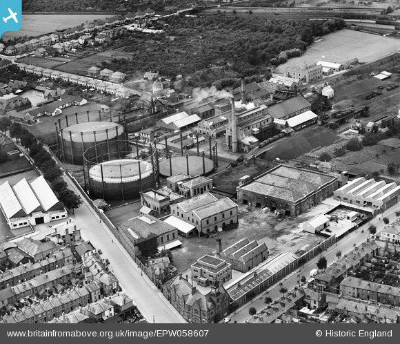
EPW058607 ENGLAND (1938). Gas Works on Lower Mill Street and environs, Alstone, 1938
© Copyright OpenStreetMap contributors and licensed by the OpenStreetMap Foundation. 2026. Cartography is licensed as CC BY-SA.
Nearby Images (9)
Details
| Title | [EPW058607] Gas Works on Lower Mill Street and environs, Alstone, 1938 |
| Reference | EPW058607 |
| Date | 13-August-1938 |
| Link | |
| Place name | ALSTONE |
| Parish | |
| District | |
| Country | ENGLAND |
| Easting / Northing | 394031, 223022 |
| Longitude / Latitude | -2.0867729173819, 51.905268656679 |
| National Grid Reference | SO940230 |
Pins

Toby Clempson |
Friday 9th of August 2013 07:19:38 AM | |

Toby Clempson |
Friday 9th of August 2013 07:19:03 AM |


![[EPW058607] Gas Works on Lower Mill Street and environs, Alstone, 1938](http://britainfromabove.org.uk/sites/all/libraries/aerofilms-images/public/100x100/EPW/058/EPW058607.jpg)
![[EPW058608] Gas Works on Lower Mill Street, Alstone, 1938](http://britainfromabove.org.uk/sites/all/libraries/aerofilms-images/public/100x100/EPW/058/EPW058608.jpg)
![[EPW058605] Gas Works on Lower Mill Street and environs, Alstone, 1938](http://britainfromabove.org.uk/sites/all/libraries/aerofilms-images/public/100x100/EPW/058/EPW058605.jpg)
![[EPW058606] Gas Works on Lower Mill Street and environs, Alstone, 1938](http://britainfromabove.org.uk/sites/all/libraries/aerofilms-images/public/100x100/EPW/058/EPW058606.jpg)
![[EPW058604] Gas Works on Lower Mill Street and environs, Alstone, 1938](http://britainfromabove.org.uk/sites/all/libraries/aerofilms-images/public/100x100/EPW/058/EPW058604.jpg)
![[EPW058603] Gas Works on Lower Mill Street and environs, Alstone, 1938](http://britainfromabove.org.uk/sites/all/libraries/aerofilms-images/public/100x100/EPW/058/EPW058603.jpg)
![[EPW059677] Cheltenham Gas Works, Tewkesbury Road and environs, Cheltenham, 1938](http://britainfromabove.org.uk/sites/all/libraries/aerofilms-images/public/100x100/EPW/059/EPW059677.jpg)
![[EPR000383] The Central School and Cheltenham Gas Works off Gloucester Road, Alstone, 1934](http://britainfromabove.org.uk/sites/all/libraries/aerofilms-images/public/100x100/EPR/000/EPR000383.jpg)
![[EPW059679] Alstone and environs, Cheltenham, from the north-east, 1938](http://britainfromabove.org.uk/sites/all/libraries/aerofilms-images/public/100x100/EPW/059/EPW059679.jpg)