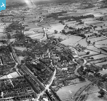
EPW058405 ENGLAND (1938). The town, Stone, from the north-west, 1938
© Copyright OpenStreetMap contributors and licensed by the OpenStreetMap Foundation. 2026. Cartography is licensed as CC BY-SA.
Nearby Images (6)
Details
| Title | [EPW058405] The town, Stone, from the north-west, 1938 |
| Reference | EPW058405 |
| Date | 28-July-1938 |
| Link | |
| Place name | STONE |
| Parish | STONE |
| District | |
| Country | ENGLAND |
| Easting / Northing | 389874, 334274 |
| Longitude / Latitude | -2.1505717401621, 52.905485513586 |
| National Grid Reference | SJ899343 |
Pins

bescotbeast |
Monday 28th of October 2013 04:47:33 AM | |

bescotbeast |
Monday 28th of October 2013 04:46:06 AM |
User Comment Contributions

Martin |
Monday 30th of December 2013 03:38:44 PM | |

bescotbeast |
Monday 9th of December 2013 11:26:46 PM |


![[EPW058405] The town, Stone, from the north-west, 1938](http://britainfromabove.org.uk/sites/all/libraries/aerofilms-images/public/100x100/EPW/058/EPW058405.jpg)
![[EPW020072] Newcastle Street and surroundings, Stone, 1927](http://britainfromabove.org.uk/sites/all/libraries/aerofilms-images/public/100x100/EPW/020/EPW020072.jpg)
![[EPW026979] St Dominic's Convent and RC Church and environs, Stone, 1929](http://britainfromabove.org.uk/sites/all/libraries/aerofilms-images/public/100x100/EPW/026/EPW026979.jpg)
![[EPW020073] Margaret Street and environs, Stone, 1927](http://britainfromabove.org.uk/sites/all/libraries/aerofilms-images/public/100x100/EPW/020/EPW020073.jpg)
![[EPW053351] St Dominic's Convent and the town centre, Stone, 1937](http://britainfromabove.org.uk/sites/all/libraries/aerofilms-images/public/100x100/EPW/053/EPW053351.jpg)
![[EPW026983] The railway station, Stone, 1929](http://britainfromabove.org.uk/sites/all/libraries/aerofilms-images/public/100x100/EPW/026/EPW026983.jpg)
