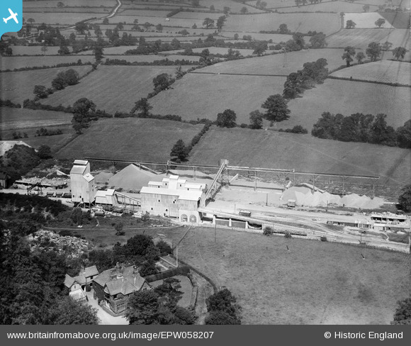
EPW058207 ENGLAND (1938). Quarry Works at Froane's Hill, Enderby, 1938
© Copyright OpenStreetMap contributors and licensed by the OpenStreetMap Foundation. 2025. Cartography is licensed as CC BY-SA.
Nearby Images (7)
Details
| Title | [EPW058207] Quarry Works at Froane's Hill, Enderby, 1938 |
| Reference | EPW058207 |
| Date | 20-July-1938 |
| Link | |
| Place name | ENDERBY |
| Parish | ENDERBY |
| District | |
| Country | ENGLAND |
| Easting / Northing | 453514, 300103 |
| Longitude / Latitude | -1.2098742128067, 52.595727950428 |
| National Grid Reference | SK535001 |


![[EPW058207] Quarry Works at Froane's Hill, Enderby, 1938](http://britainfromabove.org.uk/sites/all/libraries/aerofilms-images/public/100x100/EPW/058/EPW058207.jpg)
![[EPW058200] Quarry Works at Froane's Hill, Enderby, 1938](http://britainfromabove.org.uk/sites/all/libraries/aerofilms-images/public/100x100/EPW/058/EPW058200.jpg)
![[EPW058206] Quarry Works at Froane's Hill, Enderby, 1938](http://britainfromabove.org.uk/sites/all/libraries/aerofilms-images/public/100x100/EPW/058/EPW058206.jpg)
![[EPW058199] Quarry Works at Froane's Hill, Enderby, 1938](http://britainfromabove.org.uk/sites/all/libraries/aerofilms-images/public/100x100/EPW/058/EPW058199.jpg)
![[EPW058205] Quarry at The Warren and adjoining Quarry Works at Froane's Hill, Enderby, 1938](http://britainfromabove.org.uk/sites/all/libraries/aerofilms-images/public/100x100/EPW/058/EPW058205.jpg)
![[EPW058204] Quarry at The Warren and adjoining Quarry Works at Froane's Hill, Enderby, 1938](http://britainfromabove.org.uk/sites/all/libraries/aerofilms-images/public/100x100/EPW/058/EPW058204.jpg)
![[EPW058203] Quarry at The Warren, Enderby, 1938](http://britainfromabove.org.uk/sites/all/libraries/aerofilms-images/public/100x100/EPW/058/EPW058203.jpg)
