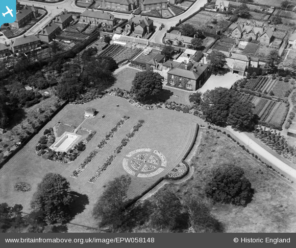
EPW058148 ENGLAND (1938). Edwinstowe House and gardens, Edwinstowe, 1938
© Copyright OpenStreetMap contributors and licensed by the OpenStreetMap Foundation. 2026. Cartography is licensed as CC BY-SA.
Nearby Images (5)
Details
| Title | [EPW058148] Edwinstowe House and gardens, Edwinstowe, 1938 |
| Reference | EPW058148 |
| Date | 19-July-1938 |
| Link | |
| Place name | EDWINSTOWE |
| Parish | EDWINSTOWE |
| District | |
| Country | ENGLAND |
| Easting / Northing | 462567, 366552 |
| Longitude / Latitude | -1.0634366404937, 53.192083872412 |
| National Grid Reference | SK626666 |
Pins

Vauni |
Tuesday 7th of July 2015 11:49:28 AM | |

totoro |
Friday 28th of February 2014 06:28:42 PM | |

totoro |
Friday 28th of February 2014 06:28:09 PM | |

totoro |
Friday 28th of February 2014 06:27:32 PM | |

totoro |
Friday 28th of February 2014 06:26:16 PM | |

totoro |
Friday 28th of February 2014 06:24:57 PM |


![[EPW058148] Edwinstowe House and gardens, Edwinstowe, 1938](http://britainfromabove.org.uk/sites/all/libraries/aerofilms-images/public/100x100/EPW/058/EPW058148.jpg)
![[EPW058149] Edwinstowe House and gardens and environs, Edwinstowe, 1938](http://britainfromabove.org.uk/sites/all/libraries/aerofilms-images/public/100x100/EPW/058/EPW058149.jpg)
![[EPW058146] Edwinstowe House and gardens and environs, Edwinstowe, 1938](http://britainfromabove.org.uk/sites/all/libraries/aerofilms-images/public/100x100/EPW/058/EPW058146.jpg)
![[EPW058147] Edwinstowe House and gardens and environs, Edwinstowe, 1938. This image has been produced from a copy-negative.](http://britainfromabove.org.uk/sites/all/libraries/aerofilms-images/public/100x100/EPW/058/EPW058147.jpg)
![[EPW058150] Edwinstowe House and gardens and the village, Edwinstowe, from the south-east, 1938](http://britainfromabove.org.uk/sites/all/libraries/aerofilms-images/public/100x100/EPW/058/EPW058150.jpg)