
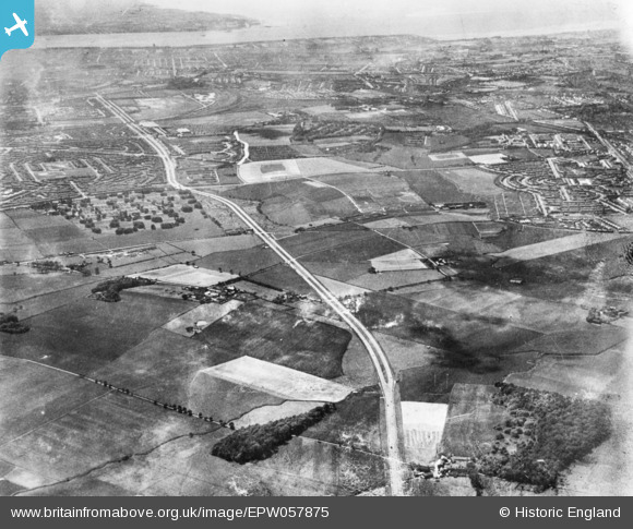
EPW057875 ENGLAND (1938). The East Lancashire Road (A580) and environs, Fazakerley, 1938. This image has been produced from a copy-negative.
© Copyright OpenStreetMap contributors and licensed by the OpenStreetMap Foundation. 2026. Cartography is licensed as CC BY-SA.
Nearby Images (2)
EPW057875
 and environs, Fazakerley, 1938. This image has been produced from a copy-negative.")
EPW057879
 and environs, Fazakerley, 1938. This image has been produced from a copy-negative.")
Details
| Title | [EPW057875] The East Lancashire Road (A580) and environs, Fazakerley, 1938. This image has been produced from a copy-negative. |
| Reference | EPW057875 |
| Date | 5-July-1938 |
| Link | |
| Place name | FAZAKERLEY |
| Parish | |
| District | |
| Country | ENGLAND |
| Easting / Northing | 339825, 396358 |
| Longitude / Latitude | -2.9064234156283, 53.460274273127 |
| National Grid Reference | SJ398964 |
Pins

austin |
Saturday 1st of July 2023 03:51:47 PM | |
|
austin |
Monday 24th of May 2021 11:15:36 AM | |
|
austin |
Friday 5th of June 2020 02:40:59 PM | |
|
austin |
Friday 5th of June 2020 02:38:21 PM | |
|
austin |
Friday 5th of June 2020 02:34:26 PM | |
|
austin |
Friday 5th of June 2020 02:32:56 PM | |
|
austin |
Friday 5th of June 2020 02:29:19 PM | |
|
austin |
Friday 5th of June 2020 01:53:51 PM | |
|
Martynj |
Friday 13th of May 2016 12:01:46 AM | |
|
Martynj |
Friday 13th of May 2016 12:00:13 AM | |
|
Martynj |
Thursday 12th of May 2016 11:57:40 PM | |
|
Martynj |
Thursday 12th of May 2016 11:56:20 PM |