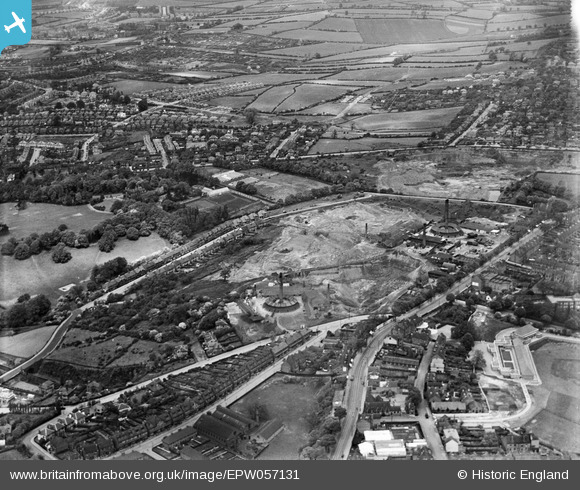
EPW057131 ENGLAND (1938). Mapperley Brick Works, Nottingham, 1938

© Copyright OpenStreetMap contributors and licensed by the OpenStreetMap Foundation. 2024. Cartography is licensed as CC BY-SA.

Nearby Images (5)

EPW057131
  0° 0m
EPW057130
  148° 132m
EPW057129
  212° 143m
EPW057132
  184° 143m
EPW057127
  161° 178m

Details

Title [EPW057131] Mapperley Brick Works, Nottingham, 1938
Reference EPW057131
Date 20-May-1938
Link
Place name NOTTINGHAM
Parish
District
Country ENGLAND
Easting / Northing 458393, 343199
Longitude / Latitude -1.1301519916234, 52.982637452384
National Grid Reference SK584432

Pins

Mapperley Methodist Church [closed 2020]

NorthChurch
Monday 27th of April 2020 01:37:00 PM
The Wells Road

NorthChurch
Monday 27th of April 2020 01:33:03 PM
Thakerays Lane

spc
Sunday 24th of November 2019 04:54:19 PM
Paddling pool. A stream fed the pool from the direction of Scout Lane and exited via a culvert that ran beneath Sherwood Station and out along the backs of houses on Cavendish Vale, into a drain at the junction of Dornoch Avenue and Winchester Street, Sherwood.

Horatio
Friday 9th of June 2017 07:50:54 PM
Beginnings of what became Somersby Road.

pim-54
Tuesday 8th of July 2014 03:39:37 PM
Clay was excavated from the whole of this field together with some excavating in the adjacent field on the other side of Breck Hill Road from the 1930s through to the mid 1950s. A railway tunnel similar to the one beneathe Woodthorpe Drive was driven beneath Breck Hill Road.

pim-54
Tuesday 8th of July 2014 03:37:58 PM
Breck Hill Road

pim-54
Tuesday 8th of July 2014 03:31:31 PM
Railway tunnel beneath Woodthorpe Drive (previously called Scout Lane)

pim-54
Tuesday 8th of July 2014 03:30:55 PM
Breck Hill fields. The site of former clay extraction.

pim-54
Tuesday 8th of July 2014 03:26:14 PM

pim-54
Tuesday 8th of July 2014 03:24:49 PM
Coronation Road

pim-54
Tuesday 8th of July 2014 03:24:02 PM
Woodthorpe Grange Park.

pim-54
Tuesday 8th of July 2014 03:22:38 PM
Site of earlier brick kiln, chimney and associated works and drying sheds.

pim-54
Tuesday 8th of July 2014 03:21:27 PM
Mapperley Rise.

pim-54
Tuesday 8th of July 2014 03:19:57 PM
Morley Avenue, Mapperley had been the site of an earlier brickmaking. The works of which were situated where there is now a cul-de-sac and small factory.

pim-54
Tuesday 8th of July 2014 03:18:57 PM
Maurice Drive: a truncated part of the vision of the directors of the Mapperley Brick Company for the reuse of previously worked-out lands for housing development. There had been plans to take the road through worked-out wooded land to Sherwood Vale. Roads given the names of Mapperley Rise, Gordon Rise, Morley Avenue and Sherwood Vale having been laid out for house building with a public transport link to the City and elsewhere being provided from the new railway station at Sherwood. Either the railway came too soon or, the speed of housebuilding was too slow for passenger receipts to grow. Added to which Nottingham Corporation's decision to rapidly expand the electric tramways had either not been known or, had been ignored, by the promoters of the Nottingham Suburban Railway. The land close to the station bounded by Maurice Drive, Mapperley Rise and Sherwood Vale was not built on in any significant way until 1960. Until 1958 large sections of it had been rented to allotment holders and fortytwo years after the last local train service had been withdrawn and the station closed in 1916.

pim-54
Tuesday 8th of July 2014 03:15:28 PM
First phase of housing on Sherwood Vale built during the late 1920s and early 1930s on land from which the best clay had been previously taken. Many of the houses on the north (Park) side of the Vale have cellars due to the contour of the land dropping steeply towards Woodthorpe Park.

pim-54
Tuesday 8th of July 2014 02:40:39 PM