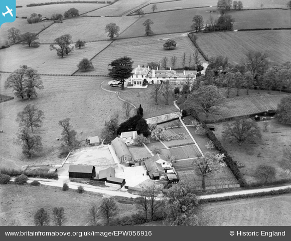
EPW056916 ENGLAND (1938). Shenley Park House, Shenley Church End, 1938
© Copyright OpenStreetMap contributors and licensed by the OpenStreetMap Foundation. 2026. Cartography is licensed as CC BY-SA.
Nearby Images (9)
Details
| Title | [EPW056916] Shenley Park House, Shenley Church End, 1938 |
| Reference | EPW056916 |
| Date | 26-April-1938 |
| Link | |
| Place name | SHENLEY CHURCH END |
| Parish | SHENLEY CHURCH END |
| District | |
| Country | ENGLAND |
| Easting / Northing | 482763, 236683 |
| Longitude / Latitude | -0.79370273780489, 52.021962030232 |
| National Grid Reference | SP828367 |
Pins
Be the first to add a comment to this image!


![[EPW056916] Shenley Park House, Shenley Church End, 1938](http://britainfromabove.org.uk/sites/all/libraries/aerofilms-images/public/100x100/EPW/056/EPW056916.jpg)
![[EPW056915] Shenley Park House, Shenley Church End, 1938](http://britainfromabove.org.uk/sites/all/libraries/aerofilms-images/public/100x100/EPW/056/EPW056915.jpg)
![[EPW056910] Shenley Park House, Shenley Church End, 1938](http://britainfromabove.org.uk/sites/all/libraries/aerofilms-images/public/100x100/EPW/056/EPW056910.jpg)
![[EPW057328] Shenley Park, Shenley Church End, 1938](http://britainfromabove.org.uk/sites/all/libraries/aerofilms-images/public/100x100/EPW/057/EPW057328.jpg)
![[EPW057329] Shenley Park and surrounding countryside, Shenley Church End, 1938](http://britainfromabove.org.uk/sites/all/libraries/aerofilms-images/public/100x100/EPW/057/EPW057329.jpg)
![[EPW056911] Shenley Park House and environs, Shenley Church End, 1938](http://britainfromabove.org.uk/sites/all/libraries/aerofilms-images/public/100x100/EPW/056/EPW056911.jpg)
![[EPW056912] Shenley Park House and environs, Shenley Church End, 1938](http://britainfromabove.org.uk/sites/all/libraries/aerofilms-images/public/100x100/EPW/056/EPW056912.jpg)
![[EPW056913] Shenley Park House and environs, Shenley Church End, from the south-west, 1938](http://britainfromabove.org.uk/sites/all/libraries/aerofilms-images/public/100x100/EPW/056/EPW056913.jpg)
![[EPW056914] Shenley Park House and environs, Shenley Church End, 1938](http://britainfromabove.org.uk/sites/all/libraries/aerofilms-images/public/100x100/EPW/056/EPW056914.jpg)