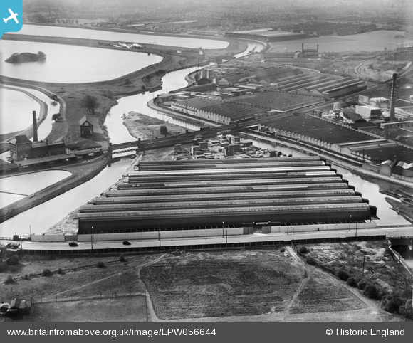
EPW056644 ENGLAND (1938). The Tottenham Wharf and Storage Co Ltd premises on Ferry Lane, Tottenham Hale, 1938
© Copyright OpenStreetMap contributors and licensed by the OpenStreetMap Foundation. 2026. Cartography is licensed as CC BY-SA.
Nearby Images (18)
Details
| Title | [EPW056644] The Tottenham Wharf and Storage Co Ltd premises on Ferry Lane, Tottenham Hale, 1938 |
| Reference | EPW056644 |
| Date | 30-March-1938 |
| Link | |
| Place name | TOTTENHAM HALE |
| Parish | |
| District | |
| Country | ENGLAND |
| Easting / Northing | 534808, 189268 |
| Longitude / Latitude | -0.053957095040916, 51.585647379909 |
| National Grid Reference | TQ348893 |


![[EPW056644] The Tottenham Wharf and Storage Co Ltd premises on Ferry Lane, Tottenham Hale, 1938](http://britainfromabove.org.uk/sites/all/libraries/aerofilms-images/public/100x100/EPW/056/EPW056644.jpg)
![[EPW056641] The Tottenham Wharf and Storage Co Ltd premises on Ferry Lane, Tottenham Hale, 1938](http://britainfromabove.org.uk/sites/all/libraries/aerofilms-images/public/100x100/EPW/056/EPW056641.jpg)
![[EPW056640] The Tottenham Wharf and Storage Co Ltd premises on Ferry Lane, Tottenham Hale, 1938](http://britainfromabove.org.uk/sites/all/libraries/aerofilms-images/public/100x100/EPW/056/EPW056640.jpg)
![[EPW056643] The Tottenham Wharf and Storage Co Ltd premises on Ferry Lane, Tottenham Hale, 1938](http://britainfromabove.org.uk/sites/all/libraries/aerofilms-images/public/100x100/EPW/056/EPW056643.jpg)
![[EPW056642] The Tottenham Wharf and Storage Co Ltd premises on Ferry Lane, Tottenham Hale, 1938](http://britainfromabove.org.uk/sites/all/libraries/aerofilms-images/public/100x100/EPW/056/EPW056642.jpg)
![[EPW056625] Harris Lebus Cabinet Works, Tottenham Hale, from the north-east, 1938](http://britainfromabove.org.uk/sites/all/libraries/aerofilms-images/public/100x100/EPW/056/EPW056625.jpg)
![[EPW056627] Harris Lebus Cabinet Works, Tottenham Hale, from the north-east, 1938](http://britainfromabove.org.uk/sites/all/libraries/aerofilms-images/public/100x100/EPW/056/EPW056627.jpg)
![[EPW055753] The Harris Lebus Cabinet Works, Tottenham Hale, 1937. This image has been produced from a damaged negative.](http://britainfromabove.org.uk/sites/all/libraries/aerofilms-images/public/100x100/EPW/055/EPW055753.jpg)
![[EPW055752] The Harris Lebus Cabinet Works, Tottenham Hale, 1937](http://britainfromabove.org.uk/sites/all/libraries/aerofilms-images/public/100x100/EPW/055/EPW055752.jpg)
![[EPW056628] Harris Lebus Cabinet Works, Tottenham Hale, from the north-east, 1938](http://britainfromabove.org.uk/sites/all/libraries/aerofilms-images/public/100x100/EPW/056/EPW056628.jpg)
![[EPW056626] Harris Lebus Cabinet Works, Tottenham Hale, 1938](http://britainfromabove.org.uk/sites/all/libraries/aerofilms-images/public/100x100/EPW/056/EPW056626.jpg)
![[EPW056629] Harris Lebus Cabinet Works, Tottenham Hale, 1938](http://britainfromabove.org.uk/sites/all/libraries/aerofilms-images/public/100x100/EPW/056/EPW056629.jpg)
![[EPW042079] The Harris Lebus Cabinet Works, Tottenham Hale, 1933](http://britainfromabove.org.uk/sites/all/libraries/aerofilms-images/public/100x100/EPW/042/EPW042079.jpg)
![[EPW006778] Harris Lebus Cabinet Works, Tottenham Hale, 1921](http://britainfromabove.org.uk/sites/all/libraries/aerofilms-images/public/100x100/EPW/006/EPW006778.jpg)
![[EPW055750] The Harris Lebus Cabinet Works, Tottenham Hale, 1937. This image has been produced from a damaged negative.](http://britainfromabove.org.uk/sites/all/libraries/aerofilms-images/public/100x100/EPW/055/EPW055750.jpg)
![[EPW055754] The Harris Lebus Cabinet Works, Tottenham Hale, 1937](http://britainfromabove.org.uk/sites/all/libraries/aerofilms-images/public/100x100/EPW/055/EPW055754.jpg)
![[EPW042080] The Harris Lebus Cabinet Works and environs, Tottenham Hale, from the north-west, 1933](http://britainfromabove.org.uk/sites/all/libraries/aerofilms-images/public/100x100/EPW/042/EPW042080.jpg)
![[EPW055755] The Harris Lebus Cabinet Works, Tottenham Hale, 1937](http://britainfromabove.org.uk/sites/all/libraries/aerofilms-images/public/100x100/EPW/055/EPW055755.jpg)
